The Pinery geodata
The Pinery (Colorado) is a populated place; located in United States in America/Denver (GMT-6) time zone. With population of 10,517 people, there are 4321 cities with bigger population in this country. Compared to other cities in United States, 51.2% of cities are located further ↑North; 82.9% of cities are located further →East and 98.8% of cities have lower elevation than The Pinery. Note1


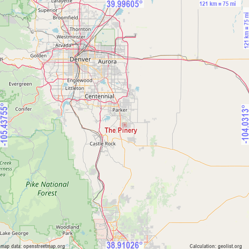
The Pinery GPS coordinates[2]
39° 27' 18.972" North, 104° 44' 3.912" West
| Map corner | latitude | longitude |
|---|---|---|
| Upper-left | 39.99605°, | -105.43755° |
| Center: | 39.45527°, | -104.73442° |
| Lower-right: | 38.91026°, | -104.0313° |
| Map W x H: | 120.7×120.7 km | = 75×75mi |
| max Lat: | 71.29058° ⇑51.2% North |
| The Pinery: | 39.45527° |
| min Lat: | ⇓48.8% South 19.06759° |
| min Long | The Pinery | max Long |
| -171.73463° | -104.73442° | -66.98998° |
| W 17.1%⇐ | ⇒82.9% E |
Elevation
Elevation of The Pinery is 1909 m = 6263 ft, and this is 1614.2 m = 5296 ft above average elevation for this country.
| Max E: |
3189 m = 10463 ft | 1.2% |
| The Pinery | 1909 m 6263 ft | |
| Avg. | 294.8 m = 967 ft | |
Min E: |
-60 m = -197 ft | 98.8% |
See also: United States elevation on elevation.city.
Geographical zone
The Pinery is located in North temperate zone (between Tropic of Cancer and the Arctic Circle). Distance of this Northern Tropic circle is 1781.1 km =1106.7 mi to South.| Distance of | km | miles | from The Pinery |
|---|---|---|---|
| North Pole | 5620 | 3492.1 | to North |
| Arctic Circle | 3014.2 | 1872.9 | to North |
| Tropic Cancer | 1781.1 | 1106.7 | to South |
| Equator | 4387 | 2726 | to South |


Nearby cities:
15 places around The Pinery: (largest is in red/bold)
• Carriage Club
16.7 km =10.4 mi,  300°
300°
• Castle Pines
13.9 km =8.6 mi,  271°
271°
• Castle Pines North
13.9 km =8.6 mi,  277°
277°
• Castle Rock
13.9 km =8.6 mi,  228°
228°
• Cottonwood
13.3 km =8.3 mi,  334°
334°
• Dove Valley
15.9 km =9.9 mi, 329°
• Elizabeth
15.8 km =9.8 mi,  131°
131°
• Foxfield
16 km =9.9 mi,  341°
341°
• Grand View Estates
12.3 km =7.6 mi,  322°
322°
• Heritage Hills
15.8 km =9.8 mi,  308°
308°
• Lone Tree
16.9 km =10.5 mi, 309°
• Meridian
13.4 km =8.3 mi, 314°
• Parker
7.4 km =4.6 mi, 341°
• Ponderosa Park
8.9 km =5.5 mi, 126°
• Stonegate
10.3 km =6.4 mi, 324°
Sources, notices
• [Note1] Compared only with cities in United States existing in our database
• [Src1] Map data: © OpenStreetMap contributors (CC-BY-SA)
• [Src2] Other city data from geonames.org with taken over terms of usage.
• [Src3] Geographical zone / Annual Mean Temperature by Robert A. Rohde @ Wikipedia
