Stratton geodata
Stratton (Colorado) is a populated place; located in United States in America/Denver (GMT-6) time zone. With population of 644 people, there are 19229 cities with bigger population in this country. Compared to other cities in United States, 57% of cities are located further ↑North; 83.5% of cities are located further →East and 100% of cities have lower elevation than Stratton. Note1


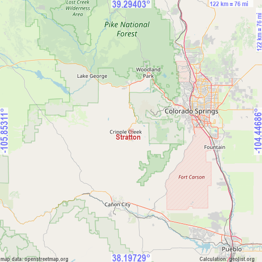
Stratton GPS coordinates[2]
38° 44' 51.972" North, 105° 8' 59.928" West
| Map corner | latitude | longitude |
|---|---|---|
| Upper-left | 39.29403°, | -105.85311° |
| Center: | 38.74777°, | -105.14998° |
| Lower-right: | 38.19729°, | -104.44686° |
| Map W x H: | 121.9×121.9 km | = 75.7×75.7mi |
| max Lat: | 71.29058° ⇑57% North |
| Stratton: | 38.74777° |
| min Lat: | ⇓43% South 19.06759° |
| min Long | Stratton | max Long |
| -171.73463° | -105.14998° | -66.98998° |
| W 16.5%⇐ | ⇒83.5% E |
Elevation
Elevation of Stratton is 3189 m = 10463 ft, and this is 2894.2 m = 9495 ft above average elevation for this country.
| Max E: |
3189 m = 10463 ft | 0% |
| Stratton | 3189 m 10463 ft | |
| Avg. | 294.8 m = 967 ft | |
Min E: |
-60 m = -197 ft | 100% |
See also: United States elevation on elevation.city.
Geographical zone
Stratton is located in North temperate zone (between Tropic of Cancer and the Arctic Circle). Distance of this Northern Tropic circle is 1702.4 km =1057.8 mi to South.| Distance of | km | miles | from Stratton |
|---|---|---|---|
| North Pole | 5698.7 | 3541 | to North |
| Arctic Circle | 3092.8 | 1921.8 | to North |
| Tropic Cancer | 1702.4 | 1057.8 | to South |
| Equator | 4308.3 | 2677.1 | to South |


Nearby cities:
15 places around Stratton: (largest is in red/bold)
• Air Force Academy
36.9 km =22.9 mi,  42°
42°
• Cascade-Chipita Park
25.2 km =15.7 mi,  30°
30°
• Cañon City
35 km =21.7 mi,  193°
193°
• Colorado Springs
30 km =18.6 mi,  71°
71°
• Cripple Creek
2.5 km =1.6 mi,  267°
267°
• Florence
39.8 km =24.7 mi,  176°
176°
• Fort Carson
31.3 km =19.4 mi,  92°
92°
• Fountain
39.6 km =24.6 mi,  100°
100°
• Green Mountain Falls
23.8 km =14.8 mi, 28°
• Lincoln Park
35.9 km =22.3 mi, 189°
• Manitou Springs
23.7 km =14.7 mi,  58°
58°
• Penrose
37.6 km =23.4 mi,  162°
162°
• Security-Widefield
37.8 km =23.5 mi, 90°
• Stratmoor
32.2 km =20 mi,  84°
84°
• Woodland Park
28.5 km =17.7 mi,  16°
16°
Sources, notices
• [Note1] Compared only with cities in United States existing in our database
• [Src1] Map data: © OpenStreetMap contributors (CC-BY-SA)
• [Src2] Other city data from geonames.org with taken over terms of usage.
• [Src3] Geographical zone / Annual Mean Temperature by Robert A. Rohde @ Wikipedia
