Security-Widefield geodata
Security-Widefield (Colorado) is a populated place; located in United States in America/Denver (GMT-6) time zone. With population of 32,882 people, there are 1516 cities with bigger population in this country. Compared to other cities in United States, 57% of cities are located further ↑North; 82.9% of cities are located further →East and 98.3% of cities have lower elevation than Security-Widefield. Note1


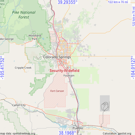
Security-Widefield GPS coordinates[2]
38° 44' 50.208" North, 104° 42' 51.804" West
| Map corner | latitude | longitude |
|---|---|---|
| Upper-left | 39.29355°, | -105.41752° |
| Center: | 38.74728°, | -104.71439° |
| Lower-right: | 38.1968°, | -104.01127° |
| Map W x H: | 121.9×121.9 km | = 75.7×75.7mi |
| max Lat: | 71.29058° ⇑57% North |
| Security-Widefield: | 38.74728° |
| min Lat: | ⇓43% South 19.06759° |
| min Long | Security-Widefi | max Long |
| -171.73463° | -104.71439° | -66.98998° |
| W 17.1%⇐ | ⇒82.9% E |
Elevation
Elevation of Security-Widefield is 1783 m = 5850 ft, and this is 1488.2 m = 4883 ft above average elevation for this country.
| Max E: |
3189 m = 10463 ft | 1.7% |
| Security-Widefield | 1783 m 5850 ft | |
| Avg. | 294.8 m = 967 ft | |
Min E: |
-60 m = -197 ft | 98.3% |
See also: United States elevation on elevation.city.
Geographical zone
Security-Widefield is located in North temperate zone (between Tropic of Cancer and the Arctic Circle). Distance of this Northern Tropic circle is 1702.4 km =1057.8 mi to South.| Distance of | km | miles | from Security-Widefield |
|---|---|---|---|
| North Pole | 5698.8 | 3541.1 | to North |
| Arctic Circle | 3092.9 | 1921.8 | to North |
| Tropic Cancer | 1702.4 | 1057.8 | to South |
| Equator | 4308.3 | 2677.1 | to South |


Nearby cities:
15 places around Security-Widefield: (largest is in red/bold)
• Air Force Academy
30.4 km =18.9 mi,  334°
334°
• Black Forest
29.6 km =18.4 mi,  2°
2°
• Cascade-Chipita Park
33.1 km =20.6 mi,  311°
311°
• Cimarron Hills
12.5 km =7.8 mi,  6°
6°
• Colorado Springs
13.4 km =8.3 mi,  316°
316°
• Cripple Creek
40.2 km =25 mi,  269°
269°
• Ellicott
30.1 km =18.7 mi,  70°
70°
• Fort Carson
6.5 km =4 mi,  260°
260°
• Fountain
7.3 km =4.5 mi,  170°
170°
• Gleneagle
34.5 km =21.4 mi,  343°
343°
• Green Mountain Falls
33.5 km =20.8 mi, 308°
• Manitou Springs
21.6 km =13.4 mi, 305°
• Stratmoor
6.4 km =4 mi,  297°
297°
• Stratton
37.8 km =23.5 mi, 270°
• Woodland Park
40.4 km =25.1 mi, 312°
Sources, notices
• [Note1] Compared only with cities in United States existing in our database
• [Src1] Map data: © OpenStreetMap contributors (CC-BY-SA)
• [Src2] Other city data from geonames.org with taken over terms of usage.
• [Src3] Geographical zone / Annual Mean Temperature by Robert A. Rohde @ Wikipedia
