Carnuel geodata
Carnuel (New Mexico) is a populated place; located in United States in America/Denver (GMT-6) time zone. With population of 1,232 people, there are 14940 cities with bigger population in this country. Compared to other cities in United States, 75% of cities are located further ↑North; 84.3% of cities are located further →East and 98.4% of cities have lower elevation than Carnuel. Note1


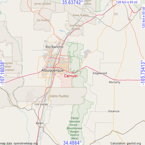
Carnuel GPS coordinates[2]
35° 3' 50.184" North, 106° 27' 26.1" West
| Map corner | latitude | longitude |
|---|---|---|
| Upper-left | 35.63742°, | -107.16038° |
| Center: | 35.06394°, | -106.45725° |
| Lower-right: | 34.4864°, | -105.75413° |
| Map W x H: | 128×128 km | = 79.5×79.5mi |
| max Lat: | 71.29058° ⇑75% North |
| Carnuel: | 35.06394° |
| min Lat: | ⇓25% South 19.06759° |
| min Long | Carnuel | max Long |
| -171.73463° | -106.45725° | -66.98998° |
| W 15.7%⇐ | ⇒84.3% E |
Elevation
Elevation of Carnuel is 1790 m = 5873 ft, and this is 1495.2 m = 4906 ft above average elevation for this country.
| Max E: |
3189 m = 10463 ft | 1.6% |
| Carnuel | 1790 m 5873 ft | |
| Avg. | 294.8 m = 967 ft | |
Min E: |
-60 m = -197 ft | 98.4% |
See also: United States elevation on elevation.city.
Geographical zone
Carnuel is located in North temperate zone (between Tropic of Cancer and the Arctic Circle). Distance of this Northern Tropic circle is 1292.8 km =803.3 mi to South.| Distance of | km | miles | from Carnuel |
|---|---|---|---|
| North Pole | 6108.3 | 3795.5 | to North |
| Arctic Circle | 3502.4 | 2176.3 | to North |
| Tropic Cancer | 1292.8 | 803.3 | to South |
| Equator | 3898.7 | 2422.5 | to South |


Nearby cities:
15 places around Carnuel: (largest is in red/bold)
• Albuquerque
17.8 km =11.1 mi,  277°
277°
• Cedar Crest
9.1 km =5.7 mi,  57°
57°
• Corrales
23.6 km =14.7 mi,  324°
324°
• Edgewood
24.2 km =15 mi,  90°
90°
• Lee Acres
19.7 km =12.2 mi,  298°
298°
• Los Ranchos de Albuquerque
20.1 km =12.5 mi, 302°
• North Valley
19.4 km =12.1 mi,  308°
308°
• Ponderosa Pine
15.5 km =9.6 mi,  128°
128°
• Rio Rancho
26.6 km =16.5 mi, 315°
• San Antonito
14.9 km =9.3 mi,  42°
42°
• Sandia Heights
12.9 km =8 mi,  346°
346°
• Sandia Knolls
17.3 km =10.7 mi,  50°
50°
• Sedillo
15.2 km =9.4 mi,  74°
74°
• South Valley
21 km =13 mi,  253°
253°
• Tijeras
6.6 km =4.1 mi, 73°
Sources, notices
• [Note1] Compared only with cities in United States existing in our database
• [Src1] Map data: © OpenStreetMap contributors (CC-BY-SA)
• [Src2] Other city data from geonames.org with taken over terms of usage.
• [Src3] Geographical zone / Annual Mean Temperature by Robert A. Rohde @ Wikipedia
