Rio Rancho geodata
Rio Rancho (New Mexico) is a populated place; located in United States in America/Denver (GMT-6) time zone. With population of 87,521 people, there are 429 cities with bigger population in this country. Compared to other cities in United States, 74.1% of cities are located further ↑North; 84.5% of cities are located further →East and 97.4% of cities have lower elevation than Rio Rancho. Note1


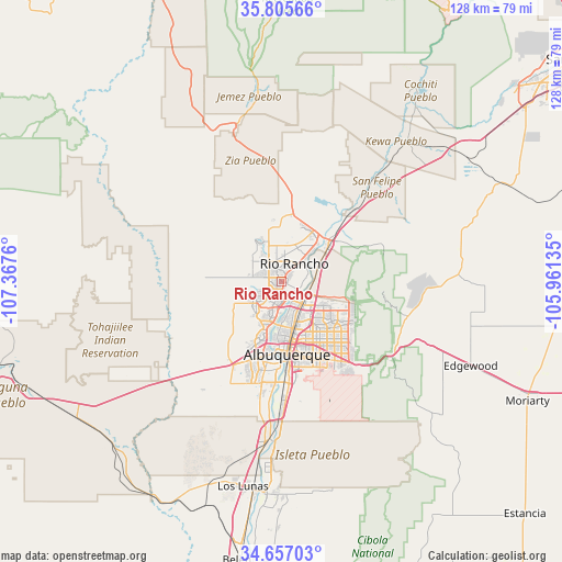
Rio Rancho GPS coordinates[2]
35° 14' 0.168" North, 106° 39' 52.092" West
| Map corner | latitude | longitude |
|---|---|---|
| Upper-left | 35.80566°, | -107.3676° |
| Center: | 35.23338°, | -106.66447° |
| Lower-right: | 34.65703°, | -105.96135° |
| Map W x H: | 127.7×127.7 km | = 79.3×79.3mi |
| max Lat: | 71.29058° ⇑74.1% North |
| Rio Rancho: | 35.23338° |
| min Lat: | ⇓25.9% South 19.06759° |
| min Long | Rio Rancho | max Long |
| -171.73463° | -106.66447° | -66.98998° |
| W 15.5%⇐ | ⇒84.5% E |
Elevation
Elevation of Rio Rancho is 1606 m = 5269 ft, and this is 1311.2 m = 4302 ft above average elevation for this country.
| Max E: |
3189 m = 10463 ft | 2.6% |
| Rio Rancho | 1606 m 5269 ft | |
| Avg. | 294.8 m = 967 ft | |
Min E: |
-60 m = -197 ft | 97.4% |
See also: Rio Rancho elevation on elevation.city.
Geographical zone
Rio Rancho is located in North temperate zone (between Tropic of Cancer and the Arctic Circle). Distance of this Northern Tropic circle is 1311.7 km =815.1 mi to South.| Distance of | km | miles | from Rio Rancho |
|---|---|---|---|
| North Pole | 6089.5 | 3783.8 | to North |
| Arctic Circle | 3483.6 | 2164.6 | to North |
| Tropic Cancer | 1311.7 | 815.1 | to South |
| Equator | 3917.6 | 2434.3 | to South |


Nearby cities:
15 places around Rio Rancho: (largest is in red/bold)
• Albuquerque
16.6 km =10.3 mi,  175°
175°
• Algodones
23.5 km =14.6 mi,  45°
45°
• Bernalillo
12.7 km =7.9 mi, 54°
• Carnuel
26.6 km =16.5 mi,  135°
135°
• Corrales
5.3 km =3.3 mi,  84°
84°
• Enchanted Hills
13.2 km =8.2 mi,  29°
29°
• Lee Acres
9.6 km =6 mi,  170°
170°
• Los Ranchos de Albuquerque
8.2 km =5.1 mi, 166°
• North Valley
7.6 km =4.7 mi,  150°
150°
• Paradise Hills
4.9 km =3 mi,  222°
222°
• Placitas
23.2 km =14.4 mi,  69°
69°
• San Felipe Pueblo
29.8 km =18.5 mi,  41°
41°
• Sandia Heights
16.9 km =10.5 mi,  111°
111°
• Santa Ana Pueblo
22.1 km =13.7 mi,  10°
10°
• South Valley
24.9 km =15.5 mi, 182°
Sources, notices
• [Note1] Compared only with cities in United States existing in our database
• [Src1] Map data: © OpenStreetMap contributors (CC-BY-SA)
• [Src2] Other city data from geonames.org with taken over terms of usage.
• [Src3] Geographical zone / Annual Mean Temperature by Robert A. Rohde @ Wikipedia
