Salem geodata
Salem (New Mexico) is a populated place; located in United States in America/Denver (GMT-6) time zone. With population of 942 people, there are 16694 cities with bigger population in this country. Compared to other cities in United States, 86.4% of cities are located further ↑North; 84.8% of cities are located further →East and 94.9% of cities have lower elevation than Salem. Note1


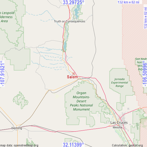
Salem GPS coordinates[2]
32° 42' 27.288" North, 107° 12' 47.088" West
| Map corner | latitude | longitude |
|---|---|---|
| Upper-left | 33.29725°, | -107.91621° |
| Center: | 32.70758°, | -107.21308° |
| Lower-right: | 32.11399°, | -106.50996° |
| Map W x H: | 131.6×131.6 km | = 81.8×81.8mi |
| max Lat: | 71.29058° ⇑86.4% North |
| Salem: | 32.70758° |
| min Lat: | ⇓13.6% South 19.06759° |
| min Long | Salem | max Long |
| -171.73463° | -107.21308° | -66.98998° |
| W 15.2%⇐ | ⇒84.8% E |
Elevation
Elevation of Salem is 1247 m = 4091 ft, and this is 952.2 m = 3124 ft above average elevation for this country.
| Max E: |
3189 m = 10463 ft | 5.1% |
| Salem | 1247 m 4091 ft | |
| Avg. | 294.8 m = 967 ft | |
Min E: |
-60 m = -197 ft | 94.9% |
See also: United States elevation on elevation.city.
Geographical zone
Salem is located in North temperate zone (between Tropic of Cancer and the Arctic Circle). Distance of this Northern Tropic circle is 1030.8 km =640.5 mi to South.| Distance of | km | miles | from Salem |
|---|---|---|---|
| North Pole | 6370.3 | 3958.3 | to North |
| Arctic Circle | 3764.4 | 2339.1 | to North |
| Tropic Cancer | 1030.8 | 640.5 | to South |
| Equator | 3636.7 | 2259.7 | to South |


Nearby cities:
15 places around Salem: (largest is in red/bold)
• Deming
70.7 km =43.9 mi,  226°
226°
• Doña Ana
51.5 km =32 mi,  133°
133°
• Elephant Butte
49.1 km =30.5 mi,  3°
3°
• Fairacres
56.5 km =35.1 mi,  142°
142°
• Hatch
7.3 km =4.5 mi, 129°
• Keeler Farm
67.3 km =41.8 mi, 229°
• La Hacienda
73.6 km =45.7 mi,  220°
220°
• Las Cruces
59.9 km =37.2 mi, 137°
• Mesilla
62.1 km =38.6 mi, 141°
• Placitas
6.3 km =3.9 mi, 138°
• Radium Springs
35.2 km =21.9 mi, 130°
• San Pablo
65.6 km =40.8 mi, 140°
• San Ysidro
54.7 km =34 mi, 136°
• Truth or Consequences
46.9 km =29.1 mi,  355°
355°
• University Park
63.9 km =39.7 mi, 137°
Sources, notices
• [Note1] Compared only with cities in United States existing in our database
• [Src1] Map data: © OpenStreetMap contributors (CC-BY-SA)
• [Src2] Other city data from geonames.org with taken over terms of usage.
• [Src3] Geographical zone / Annual Mean Temperature by Robert A. Rohde @ Wikipedia
