Doña Ana geodata
Doña Ana (New Mexico) is a populated place; located in United States in America/Denver (GMT-6) time zone. With population of 1,211 people, there are 15068 cities with bigger population in this country. Compared to other cities in United States, 87.5% of cities are located further ↑North; 84.6% of cities are located further →East and 94.6% of cities have lower elevation than Doña Ana. Note1


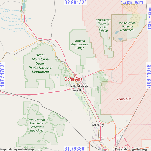
Doña Ana GPS coordinates[2]
32° 23' 22.344" North, 106° 48' 50.04" West
| Map corner | latitude | longitude |
|---|---|---|
| Upper-left | 32.98132°, | -107.51703° |
| Center: | 32.38954°, | -106.8139° |
| Lower-right: | 31.79386°, | -106.11078° |
| Map W x H: | 132×132 km | = 82×82mi |
| max Lat: | 71.29058° ⇑87.5% North |
| Doña Ana: | 32.38954° |
| min Lat: | ⇓12.5% South 19.06759° |
| min Long | Doña Ana | max Long |
| -171.73463° | -106.8139° | -66.98998° |
| W 15.4%⇐ | ⇒84.6% E |
Elevation
Elevation of Doña Ana is 1207 m = 3960 ft, and this is 912.2 m = 2993 ft above average elevation for this country.
| Max E: |
3189 m = 10463 ft | 5.4% |
| Doña Ana | 1207 m 3960 ft | |
| Avg. | 294.8 m = 967 ft | |
Min E: |
-60 m = -197 ft | 94.6% |
See also: United States elevation on elevation.city.
Geographical zone
Doña Ana is located in North temperate zone (between Tropic of Cancer and the Arctic Circle). Distance of this Northern Tropic circle is 995.5 km =618.6 mi to South.| Distance of | km | miles | from Doña Ana |
|---|---|---|---|
| North Pole | 6405.7 | 3980.3 | to North |
| Arctic Circle | 3799.8 | 2361.1 | to North |
| Tropic Cancer | 995.5 | 618.6 | to South |
| Equator | 3601.4 | 2237.8 | to South |


Nearby cities:
15 places around Doña Ana: (largest is in red/bold)
• Berino
39.8 km =24.7 mi,  152°
152°
• Chamberino
40.7 km =25.3 mi,  162°
162°
• Fairacres
10 km =6.2 mi,  197°
197°
• Hatch
44.2 km =27.5 mi,  313°
313°
• La Mesa
31.4 km =19.5 mi, 161°
• Las Cruces
9.2 km =5.7 mi, 158°
• Mesilla
13.3 km =8.3 mi,  174°
174°
• Mesquite
27.3 km =17 mi, 156°
• Radium Springs
16.4 km =10.2 mi,  319°
319°
• San Miguel
27.1 km =16.8 mi, 164°
• San Pablo
16 km =9.9 mi, 166°
• San Ysidro
4.3 km =2.7 mi,  176°
176°
• University Park
13.1 km =8.1 mi, 154°
• Vado
34 km =21.1 mi, 155°
• White Sands
31.4 km =19.5 mi,  91°
91°
Sources, notices
• [Note1] Compared only with cities in United States existing in our database
• [Src1] Map data: © OpenStreetMap contributors (CC-BY-SA)
• [Src2] Other city data from geonames.org with taken over terms of usage.
• [Src3] Geographical zone / Annual Mean Temperature by Robert A. Rohde @ Wikipedia
