Zephyr Cove geodata
Zephyr Cove (Nevada) is a populated place; located in United States in America/Los_Angeles (GMT-7) time zone. With population of 565 people, there are 20091 cities with bigger population in this country. Compared to other cities in United States, 54.8% of cities are located further ↑North; 92.8% of cities are located further →East and 98.9% of cities have lower elevation than Zephyr Cove. Note1


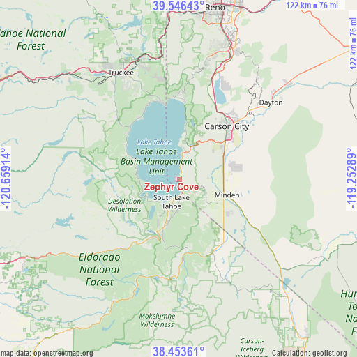
Zephyr Cove GPS coordinates[2]
39° 0' 7.668" North, 119° 57' 21.636" West
| Map corner | latitude | longitude |
|---|---|---|
| Upper-left | 39.54643°, | -120.65914° |
| Center: | 39.00213°, | -119.95601° |
| Lower-right: | 38.45361°, | -119.25289° |
| Map W x H: | 121.5×121.5 km | = 75.5×75.5mi |
| max Lat: | 71.29058° ⇑54.8% North |
| Zephyr Cove: | 39.00213° |
| min Lat: | ⇓45.2% South 19.06759° |
| min Long | Zephyr Cove | max Long |
| -171.73463° | -119.95601° | -66.98998° |
| W 7.2%⇐ | ⇒92.8% E |
Elevation
Elevation of Zephyr Cove is 1939 m = 6362 ft, and this is 1644.2 m = 5394 ft above average elevation for this country.
| Max E: |
3189 m = 10463 ft | 1.1% |
| Zephyr Cove | 1939 m 6362 ft | |
| Avg. | 294.8 m = 967 ft | |
Min E: |
-60 m = -197 ft | 98.9% |
See also: United States elevation on elevation.city.
Geographical zone
Zephyr Cove is located in North temperate zone (between Tropic of Cancer and the Arctic Circle). Distance of this Northern Tropic circle is 1730.7 km =1075.4 mi to South.| Distance of | km | miles | from Zephyr Cove |
|---|---|---|---|
| North Pole | 5670.4 | 3523.4 | to North |
| Arctic Circle | 3064.5 | 1904.2 | to North |
| Tropic Cancer | 1730.7 | 1075.4 | to South |
| Equator | 4336.6 | 2694.6 | to South |


Nearby cities:
15 places around Zephyr Cove: (largest is in red/bold)
• Carson City
24.3 km =15.1 mi,  42°
42°
• Dollar Point
24.1 km =15 mi,  328°
328°
• East Valley
23.1 km =14.4 mi,  106°
106°
• Fish Springs
26.9 km =16.7 mi,  101°
101°
• Gardnerville
19.1 km =11.9 mi, 110°
• Gardnerville Ranchos
22.5 km =14 mi,  124°
124°
• Genoa
9.4 km =5.8 mi,  88°
88°
• Indian Hills
17.5 km =10.9 mi,  57°
57°
• Johnson Lane
20.8 km =12.9 mi,  75°
75°
• Kingsbury
5.1 km =3.2 mi, 123°
• Minden
17.3 km =10.7 mi, 107°
• South Lake Tahoe
8 km =5 mi,  197°
197°
• Stateline
4.6 km =2.9 mi,  162°
162°
• Sunnyside-Tahoe City
24.2 km =15 mi,  312°
312°
• Tahoma
16.6 km =10.3 mi,  296°
296°
Sources, notices
• [Note1] Compared only with cities in United States existing in our database
• [Src1] Map data: © OpenStreetMap contributors (CC-BY-SA)
• [Src2] Other city data from geonames.org with taken over terms of usage.
• [Src3] Geographical zone / Annual Mean Temperature by Robert A. Rohde @ Wikipedia
