Sunnyside-Tahoe City geodata
Sunnyside-Tahoe City (California) is a populated place; located in United States in America/Los_Angeles (GMT-7) time zone. With population of 1,557 people, there are 13450 cities with bigger population in this country. Compared to other cities in United States, 53.4% of cities are located further ↑North; 93% of cities are located further →East and 99.4% of cities have lower elevation than Sunnyside-Tahoe City. Note1


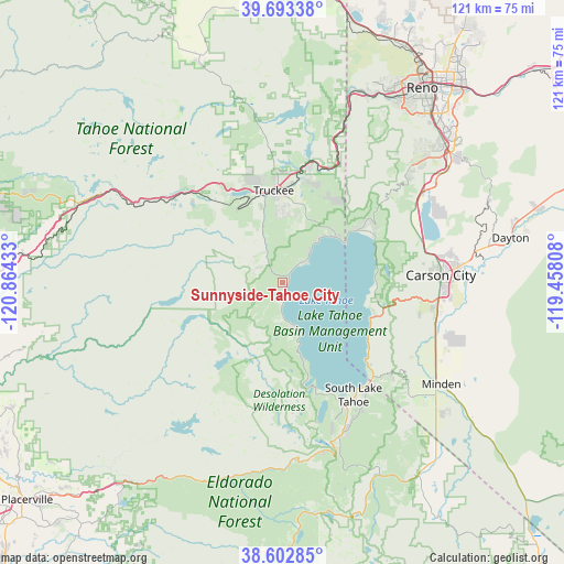
Sunnyside-Tahoe City GPS coordinates[2]
39° 9' 0.828" North, 120° 9' 40.32" West
| Map corner | latitude | longitude |
|---|---|---|
| Upper-left | 39.69338°, | -120.86433° |
| Center: | 39.15023°, | -120.1612° |
| Lower-right: | 38.60285°, | -119.45808° |
| Map W x H: | 121.3×121.3 km | = 75.4×75.4mi |
| max Lat: | 71.29058° ⇑53.4% North |
| Sunnyside-Tahoe City: | 39.15023° |
| min Lat: | ⇓46.6% South 19.06759° |
| min Long | Sunnyside-Tahoe | max Long |
| -171.73463° | -120.1612° | -66.98998° |
| W 7%⇐ | ⇒93% E |
Elevation
Elevation of Sunnyside-Tahoe City is 2081 m = 6827 ft, and this is 1786.2 m = 5860 ft above average elevation for this country.
| Max E: |
3189 m = 10463 ft | 0.59999999999999% |
| Sunnyside-Tahoe City | 2081 m 6827 ft | |
| Avg. | 294.8 m = 967 ft | |
Min E: |
-60 m = -197 ft | 99.4% |
See also: United States elevation on elevation.city.
Geographical zone
Sunnyside-Tahoe City is located in North temperate zone (between Tropic of Cancer and the Arctic Circle). Distance of this Northern Tropic circle is 1747.2 km =1085.7 mi to South.| Distance of | km | miles | from Sunnyside-Tahoe City |
|---|---|---|---|
| North Pole | 5654 | 3513.2 | to North |
| Arctic Circle | 3048.1 | 1894 | to North |
| Tropic Cancer | 1747.2 | 1085.7 | to South |
| Equator | 4353.1 | 2704.9 | to South |


Nearby cities:
15 places around Sunnyside-Tahoe City: (largest is in red/bold)
• Carnelian Bay
10.9 km =6.8 mi,  38°
38°
• Carson City
34 km =21.1 mi,  87°
87°
• Dollar Point
6.7 km =4.2 mi,  51°
51°
• Genoa
31.6 km =19.6 mi,  120°
120°
• Incline Village
19.7 km =12.2 mi,  55°
55°
• Indian Hills
33.3 km =20.7 mi,  102°
102°
• Johnson Lane
39.6 km =24.6 mi,  106°
106°
• Kings Beach
15.1 km =9.4 mi, 50°
• Kingsbury
29.2 km =18.1 mi,  131°
131°
• South Lake Tahoe
28.6 km =17.8 mi,  147°
147°
• Stateline
28.3 km =17.6 mi,  137°
137°
• Tahoe Vista
13.8 km =8.6 mi, 43°
• Tahoma
9.6 km =6 mi,  162°
162°
• Truckee
19.9 km =12.4 mi,  354°
354°
• Zephyr Cove
24.2 km =15 mi, 132°
Sources, notices
• [Note1] Compared only with cities in United States existing in our database
• [Src1] Map data: © OpenStreetMap contributors (CC-BY-SA)
• [Src2] Other city data from geonames.org with taken over terms of usage.
• [Src3] Geographical zone / Annual Mean Temperature by Robert A. Rohde @ Wikipedia
