Texhoma geodata
Texhoma (Oklahoma) is a populated place; located in United States in America/Chicago (GMT-5) time zone. With population of 969 people, there are 16499 cities with bigger population in this country. Compared to other cities in United States, 68% of cities are located further ↑North; 81.7% of cities are located further →East and 93.8% of cities have lower elevation than Texhoma. Note1


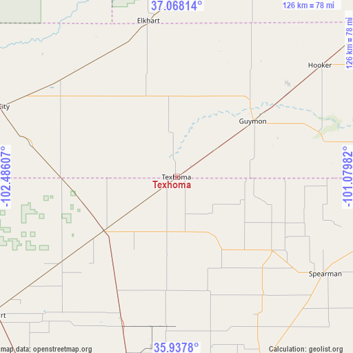
Texhoma GPS coordinates[2]
36° 30' 18.108" North, 101° 46' 58.584" West
| Map corner | latitude | longitude |
|---|---|---|
| Upper-left | 37.06814°, | -102.48607° |
| Center: | 36.50503°, | -101.78294° |
| Lower-right: | 35.9378°, | -101.07982° |
| Map W x H: | 125.7×125.7 km | = 78.1×78.1mi |
| max Lat: | 71.29058° ⇑68% North |
| Texhoma: | 36.50503° |
| min Lat: | ⇓32% South 19.06759° |
| min Long | Texhoma | max Long |
| -171.73463° | -101.78294° | -66.98998° |
| W 18.3%⇐ | ⇒81.7% E |
Elevation
Elevation of Texhoma is 1063 m = 3488 ft, and this is 768.2 m = 2520 ft above average elevation for this country.
| Max E: |
3189 m = 10463 ft | 6.2% |
| Texhoma | 1063 m 3488 ft | |
| Avg. | 294.8 m = 967 ft | |
Min E: |
-60 m = -197 ft | 93.8% |
See also: United States elevation on elevation.city.
Geographical zone
Texhoma is located in North temperate zone (between Tropic of Cancer and the Arctic Circle). Distance of this Northern Tropic circle is 1453.1 km =902.9 mi to South.| Distance of | km | miles | from Texhoma |
|---|---|---|---|
| North Pole | 5948.1 | 3696 | to North |
| Arctic Circle | 3342.2 | 2076.7 | to North |
| Tropic Cancer | 1453.1 | 902.9 | to South |
| Equator | 4059 | 2522.1 | to South |


Nearby cities:
15 places around Texhoma: (largest is in red/bold)
• Boise City
69.8 km =43.4 mi,  290°
290°
• Cactus
54.1 km =33.6 mi,  201°
201°
• Dalhart
82.1 km =51 mi,  232°
232°
• Dumas
73.1 km =45.4 mi,  193°
193°
• Elkhart
56.7 km =35.2 mi,  350°
350°
• Goodwell
16.5 km =10.3 mi,  52°
52°
• Gruver
43 km =26.7 mi,  128°
128°
• Guymon
33.4 km =20.8 mi, 53°
• Hooker
64.3 km =40 mi, 52°
• Hugoton
83.9 km =52.1 mi,  27°
27°
• Spearman
62.9 km =39.1 mi,  122°
122°
• Stinnett
81.3 km =50.5 mi,  157°
157°
• Stratford
32 km =19.9 mi, 234°
• Sunray
54.4 km =33.8 mi,  183°
183°
• Tyrone
81.1 km =50.4 mi, 52°
Sources, notices
• [Note1] Compared only with cities in United States existing in our database
• [Src1] Map data: © OpenStreetMap contributors (CC-BY-SA)
• [Src2] Other city data from geonames.org with taken over terms of usage.
• [Src3] Geographical zone / Annual Mean Temperature by Robert A. Rohde @ Wikipedia
