Stratford geodata
Stratford (Texas) is a seat of a second-order administrative division; located in United States in America/Chicago (GMT-5) time zone. With population of 2,073 people, there are 11709 cities with bigger population in this country. Compared to other cities in United States, 68.7% of cities are located further ↑North; 81.9% of cities are located further →East and 94.2% of cities have lower elevation than Stratford. Note1


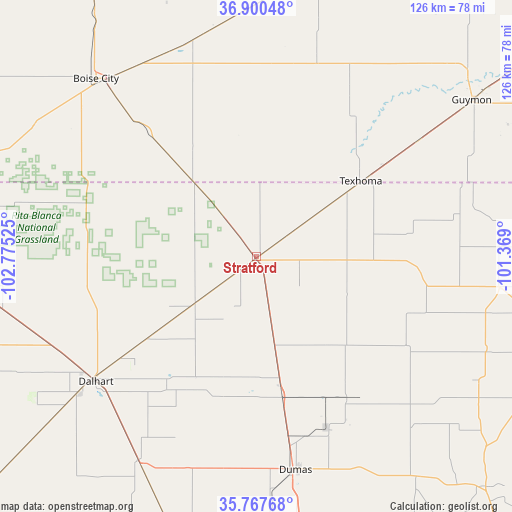
Stratford GPS coordinates[2]
36° 20' 10.104" North, 102° 4' 19.632" West
| Map corner | latitude | longitude |
|---|---|---|
| Upper-left | 36.90048°, | -102.77525° |
| Center: | 36.33614°, | -102.07212° |
| Lower-right: | 35.76768°, | -101.369° |
| Map W x H: | 126×126 km | = 78.3×78.3mi |
| max Lat: | 71.29058° ⇑68.7% North |
| Stratford: | 36.33614° |
| min Lat: | ⇓31.3% South 19.06759° |
| min Long | Stratford | max Long |
| -171.73463° | -102.07212° | -66.98998° |
| W 18.1%⇐ | ⇒81.9% E |
Elevation
Elevation of Stratford is 1128 m = 3701 ft, and this is 833.2 m = 2734 ft above average elevation for this country.
| Max E: |
3189 m = 10463 ft | 5.8% |
| Stratford | 1128 m 3701 ft | |
| Avg. | 294.8 m = 967 ft | |
Min E: |
-60 m = -197 ft | 94.2% |
See also: United States elevation on elevation.city.
Geographical zone
Stratford is located in North temperate zone (between Tropic of Cancer and the Arctic Circle). Distance of this Northern Tropic circle is 1434.3 km =891.2 mi to South.| Distance of | km | miles | from Stratford |
|---|---|---|---|
| North Pole | 5966.9 | 3707.7 | to North |
| Arctic Circle | 3361 | 2088.4 | to North |
| Tropic Cancer | 1434.3 | 891.2 | to South |
| Equator | 4040.2 | 2510.5 | to South |


Nearby cities:
15 places around Stratford: (largest is in red/bold)
• Boise City
58.9 km =36.6 mi,  317°
317°
• Cactus
32.2 km =20 mi,  168°
168°
• Channing
76.2 km =47.3 mi,  197°
197°
• Dalhart
50.1 km =31.1 mi,  232°
232°
• Dumas
53.1 km =33 mi, 170°
• Elkhart
76.5 km =47.5 mi,  12°
12°
• Goodwell
48.4 km =30.1 mi,  53°
53°
• Gruver
60.2 km =37.4 mi,  97°
97°
• Guymon
65.4 km =40.6 mi, 53°
• Hartley
58 km =36 mi,  210°
210°
• Spearman
80.3 km =49.9 mi, 100°
• Stinnett
80 km =49.7 mi,  135°
135°
• Sunray
41.9 km =26 mi,  147°
147°
• Texhoma
32 km =19.9 mi, 54°
• Texline
85.4 km =53.1 mi,  273°
273°
Sources, notices
• [Note1] Compared only with cities in United States existing in our database
• [Src1] Map data: © OpenStreetMap contributors (CC-BY-SA)
• [Src2] Other city data from geonames.org with taken over terms of usage.
• [Src3] Geographical zone / Annual Mean Temperature by Robert A. Rohde @ Wikipedia
