Genola geodata
Genola (Utah) is a populated place; located in United States in America/Denver (GMT-6) time zone. With population of 1,419 people, there are 14021 cities with bigger population in this country. Compared to other cities in United States, 53.5% of cities are located further ↓South; 87.1% of cities are located further →East and 96% of cities have lower elevation than Genola. Note1


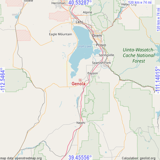
Genola GPS coordinates[2]
39° 59' 46.824" North, 111° 50' 35.772" West
| Map corner | latitude | longitude |
|---|---|---|
| Upper-left | 40.53287°, | -112.5464° |
| Center: | 39.99634°, | -111.84327° |
| Lower-right: | 39.45556°, | -111.14015° |
| Map W x H: | 119.8×119.8 km | = 74.4×74.4mi |
| max Lat: | 71.29058° ⇑46.5% North |
| Genola: | 39.99634° |
| min Lat: | ⇓53.5% South 19.06759° |
| min Long | Genola | max Long |
| -171.73463° | -111.84327° | -66.98998° |
| W 12.9%⇐ | ⇒87.1% E |
Elevation
Elevation of Genola is 1405 m = 4610 ft, and this is 1110.2 m = 3642 ft above average elevation for this country.
| Max E: |
3189 m = 10463 ft | 4% |
| Genola | 1405 m 4610 ft | |
| Avg. | 294.8 m = 967 ft | |
Min E: |
-60 m = -197 ft | 96% |
See also: United States elevation on elevation.city.
Geographical zone
Genola is located in North temperate zone (between Tropic of Cancer and the Arctic Circle). Distance of this Northern Tropic circle is 1841.3 km =1144.1 mi to South.| Distance of | km | miles | from Genola |
|---|---|---|---|
| North Pole | 5559.9 | 3454.8 | to North |
| Arctic Circle | 2954 | 1835.5 | to North |
| Tropic Cancer | 1841.3 | 1144.1 | to South |
| Equator | 4447.2 | 2763.4 | to South |


Nearby cities:
15 places around Genola: (largest is in red/bold)
• Benjamin
14.8 km =9.2 mi,  40°
40°
• Elk Ridge
14.3 km =8.9 mi,  83°
83°
• Eureka
24.1 km =15 mi,  258°
258°
• Goshen
6.9 km =4.3 mi,  225°
225°
• Lake Shore
16.9 km =10.5 mi,  34°
34°
• Mapleton
27 km =16.8 mi,  56°
56°
• Mona
20.1 km =12.5 mi,  182°
182°
• Payson
10.9 km =6.8 mi, 60°
• Rocky Ridge
8.1 km =5 mi,  170°
170°
• Salem
15.8 km =9.8 mi,  66°
66°
• Santaquin
5.5 km =3.4 mi,  115°
115°
• Spanish Fork
20.8 km =12.9 mi,  50°
50°
• Springville
27.3 km =17 mi, 46°
• West Mountain
8.6 km =5.3 mi, 33°
• Woodland Hills
16.7 km =10.4 mi, 82°
Sources, notices
• [Note1] Compared only with cities in United States existing in our database
• [Src1] Map data: © OpenStreetMap contributors (CC-BY-SA)
• [Src2] Other city data from geonames.org with taken over terms of usage.
• [Src3] Geographical zone / Annual Mean Temperature by Robert A. Rohde @ Wikipedia
