Bayview geodata
Bayview (California) is a populated place; located in United States in America/Los_Angeles (GMT-7) time zone. With population of 2,510 people, there are 10586 cities with bigger population in this country. Compared to other cities in United States, 62.7% of cities are located further ↓South; 98.7% of cities are located further →East and 89.1% of cities have higher elevation than Bayview. Note1


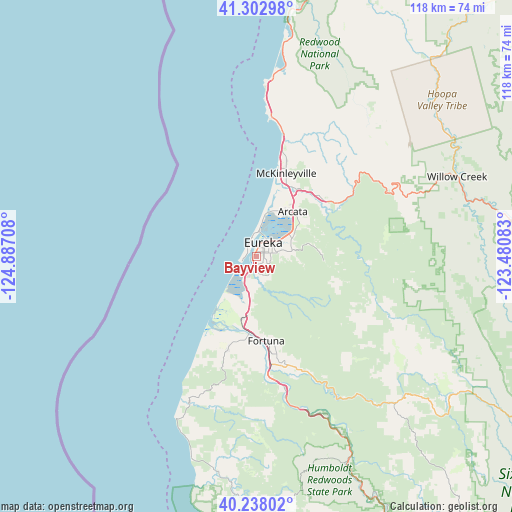
Bayview GPS coordinates[2]
40° 46' 21.468" North, 124° 11' 2.22" West
| Map corner | latitude | longitude |
|---|---|---|
| Upper-left | 41.30298°, | -124.88708° |
| Center: | 40.77263°, | -124.18395° |
| Lower-right: | 40.23802°, | -123.48083° |
| Map W x H: | 118.4×118.4 km | = 73.6×73.6mi |
| max Lat: | 71.29058° ⇑37.3% North |
| Bayview: | 40.77263° |
| min Lat: | ⇓62.7% South 19.06759° |
| min Long | Bayview | max Long |
| -171.73463° | -124.18395° | -66.98998° |
| W 1.3%⇐ | ⇒98.7% E |
Elevation
Elevation of Bayview is 18 m = 59 ft, and this is 276.8 m = 908 ft below average elevation for this country.
| Max E: |
3189 m = 10463 ft | 89.1% |
| Avg. | 294.8 m = 967 ft | |
| Bayview | 18 m = 59 ft | |
Min E: |
-60 m = -197 ft | 10.9% |
See also: United States elevation on elevation.city.
Geographical zone
Bayview is located in North temperate zone (between Tropic of Cancer and the Arctic Circle). Distance of this Northern Tropic circle is 1927.6 km =1197.8 mi to South.| Distance of | km | miles | from Bayview |
|---|---|---|---|
| North Pole | 5473.6 | 3401.1 | to North |
| Arctic Circle | 2867.7 | 1781.9 | to North |
| Tropic Cancer | 1927.6 | 1197.8 | to South |
| Equator | 4533.5 | 2817 | to South |


Nearby cities:
15 places around Bayview: (largest is in red/bold)
• Arcata
13.5 km =8.4 mi,  39°
39°
• Bayside
12.8 km =8 mi,  52°
52°
• Blue Lake
20.8 km =12.9 mi, 53°
• Cutten
3.5 km =2.2 mi,  95°
95°
• Eureka
3.7 km =2.3 mi,  27°
27°
• Ferndale
22.9 km =14.2 mi,  197°
197°
• Fortuna
19.5 km =12.1 mi,  173°
173°
• Humboldt Hill
5.2 km =3.2 mi,  185°
185°
• Indianola
9.6 km =6 mi,  62°
62°
• Indianola
10.5 km =6.5 mi, 203°
• Loleta
15.1 km =9.4 mi, 193°
• Manila
9 km =5.6 mi,  11°
11°
• McKinleyville
20.6 km =12.8 mi,  19°
19°
• Myrtletown
4.9 km =3 mi,  68°
68°
• Pine Hills
5.1 km =3.2 mi,  148°
148°
Sources, notices
• [Note1] Compared only with cities in United States existing in our database
• [Src1] Map data: © OpenStreetMap contributors (CC-BY-SA)
• [Src2] Other city data from geonames.org with taken over terms of usage.
• [Src3] Geographical zone / Annual Mean Temperature by Robert A. Rohde @ Wikipedia
