Manila geodata
Manila (California) is a populated place; located in United States in America/Los_Angeles (GMT-7) time zone. With population of 784 people, there are 17947 cities with bigger population in this country. Compared to other cities in United States, 64% of cities are located further ↓South; 98.7% of cities are located further →East and 99.6% of cities have higher elevation than Manila. Note1


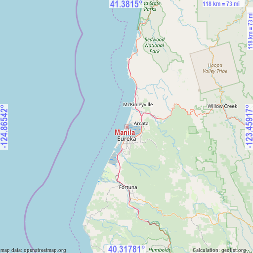
Manila GPS coordinates[2]
40° 51' 6.444" North, 124° 9' 44.244" West
| Map corner | latitude | longitude |
|---|---|---|
| Upper-left | 41.3815°, | -124.86542° |
| Center: | 40.85179°, | -124.16229° |
| Lower-right: | 40.31781°, | -123.45917° |
| Map W x H: | 118.3×118.3 km | = 73.5×73.5mi |
| max Lat: | 71.29058° ⇑36% North |
| Manila: | 40.85179° |
| min Lat: | ⇓64% South 19.06759° |
| min Long | Manila | max Long |
| -171.73463° | -124.16229° | -66.98998° |
| W 1.3%⇐ | ⇒98.7% E |
Elevation
Elevation of Manila is 1 m = 3 ft, and this is 293.8 m = 964 ft below average elevation for this country.
| Max E: |
3189 m = 10463 ft | 99.6% |
| Avg. | 294.8 m = 967 ft | |
| Manila | 1 m = 3 ft | |
Min E: |
-60 m = -197 ft | 0.4% |
See also: United States elevation on elevation.city.
Geographical zone
Manila is located in North temperate zone (between Tropic of Cancer and the Arctic Circle). Distance of this Northern Tropic circle is 1936.4 km =1203.2 mi to South.| Distance of | km | miles | from Manila |
|---|---|---|---|
| North Pole | 5464.8 | 3395.7 | to North |
| Arctic Circle | 2858.9 | 1776.4 | to North |
| Tropic Cancer | 1936.4 | 1203.2 | to South |
| Equator | 4542.3 | 2822.5 | to South |


Nearby cities:
15 places around Manila: (largest is in red/bold)
• Arcata
6.9 km =4.3 mi,  76°
76°
• Bayside
8.4 km =5.2 mi,  97°
97°
• Bayview
9 km =5.6 mi,  191°
191°
• Blue Lake
15.4 km =9.6 mi, 77°
• Cutten
9.3 km =5.8 mi,  169°
169°
• Eureka
5.5 km =3.4 mi,  181°
181°
• Fieldbrook
16.5 km =10.3 mi,  40°
40°
• Humboldt Hill
14.2 km =8.8 mi, 189°
• Indianola
8 km =5 mi,  123°
123°
• Indianola
19.4 km =12.1 mi,  198°
198°
• Loleta
24 km =14.9 mi, 192°
• McKinleyville
11.7 km =7.3 mi,  26°
26°
• Myrtletown
7.5 km =4.7 mi,  159°
159°
• Pine Hills
13.2 km =8.2 mi, 176°
• Westhaven-Moonstone
22.1 km =13.7 mi,  13°
13°
Sources, notices
• [Note1] Compared only with cities in United States existing in our database
• [Src1] Map data: © OpenStreetMap contributors (CC-BY-SA)
• [Src2] Other city data from geonames.org with taken over terms of usage.
• [Src3] Geographical zone / Annual Mean Temperature by Robert A. Rohde @ Wikipedia
