Ashton geodata
Ashton (Idaho) is a populated place; located in United States in America/Boise (GMT-6) time zone. With population of 1,051 people, there are 15950 cities with bigger population in this country. Compared to other cities in United States, 88.7% of cities are located further ↓South; 86.6% of cities are located further →East and 97.4% of cities have lower elevation than Ashton. Note1


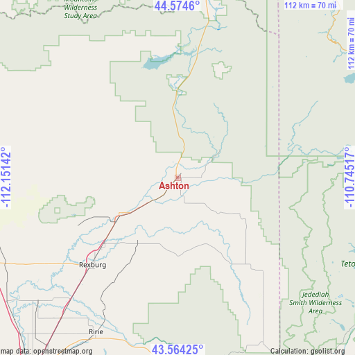
Ashton GPS coordinates[2]
44° 4' 17.688" North, 111° 26' 53.844" West
| Map corner | latitude | longitude |
|---|---|---|
| Upper-left | 44.5746°, | -112.15142° |
| Center: | 44.07158°, | -111.44829° |
| Lower-right: | 43.56425°, | -110.74517° |
| Map W x H: | 112.3×112.3 km | = 69.8×69.8mi |
| max Lat: | 71.29058° ⇑11.3% North |
| Ashton: | 44.07158° |
| min Lat: | ⇓88.7% South 19.06759° |
| min Long | Ashton | max Long |
| -171.73463° | -111.44829° | -66.98998° |
| W 13.4%⇐ | ⇒86.6% E |
Elevation
Elevation of Ashton is 1604 m = 5262 ft, and this is 1309.2 m = 4295 ft above average elevation for this country.
| Max E: |
3189 m = 10463 ft | 2.6% |
| Ashton | 1604 m 5262 ft | |
| Avg. | 294.8 m = 967 ft | |
Min E: |
-60 m = -197 ft | 97.4% |
See also: United States elevation on elevation.city.
Geographical zone
Ashton is located in North temperate zone (between Tropic of Cancer and the Arctic Circle). Distance of this Northern Tropic circle is 2294.4 km =1425.7 mi to South.| Distance of | km | miles | from Ashton |
|---|---|---|---|
| North Pole | 5106.8 | 3173.2 | to North |
| Arctic Circle | 2500.9 | 1554 | to North |
| Tropic Cancer | 2294.4 | 1425.7 | to South |
| Equator | 4900.3 | 3044.9 | to South |


Nearby cities:
15 places around Ashton: (largest is in red/bold)
• Driggs
47.2 km =29.3 mi,  145°
145°
• Dubois
63.5 km =39.5 mi,  280°
280°
• Iona
72 km =44.7 mi,  212°
212°
• Lincoln
74.7 km =46.4 mi, 213°
• Menan
58.4 km =36.3 mi,  228°
228°
• Rexburg
38.6 km =24 mi, 225°
• Rigby
58 km =36 mi,  220°
220°
• Ririe
55.4 km =34.4 mi, 208°
• Roberts
66.9 km =41.6 mi, 234°
• Saint Anthony
22.1 km =13.7 mi,  237°
237°
• Sugar City
32.6 km =20.3 mi, 227°
• Teton
27.6 km =17.1 mi, 221°
• Ucon
67.1 km =41.7 mi, 218°
• Victor
58.7 km =36.5 mi, 152°
• West Yellowstone
71.1 km =44.2 mi,  22°
22°
Sources, notices
• [Note1] Compared only with cities in United States existing in our database
• [Src1] Map data: © OpenStreetMap contributors (CC-BY-SA)
• [Src2] Other city data from geonames.org with taken over terms of usage.
• [Src3] Geographical zone / Annual Mean Temperature by Robert A. Rohde @ Wikipedia
