Rigby geodata
Rigby (Idaho) is a seat of a second-order administrative division; located in United States in America/Boise (GMT-6) time zone. With population of 4,029 people, there are 8180 cities with bigger population in this country. Compared to other cities in United States, 87.1% of cities are located further ↓South; 87.3% of cities are located further →East and 96.5% of cities have lower elevation than Rigby. Note1


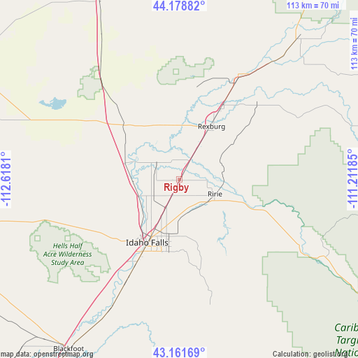
Rigby GPS coordinates[2]
43° 40' 20.676" North, 111° 54' 53.892" West
| Map corner | latitude | longitude |
|---|---|---|
| Upper-left | 44.17882°, | -112.6181° |
| Center: | 43.67241°, | -111.91497° |
| Lower-right: | 43.16169°, | -111.21185° |
| Map W x H: | 113.1×113.1 km | = 70.3×70.3mi |
| max Lat: | 71.29058° ⇑12.9% North |
| Rigby: | 43.67241° |
| min Lat: | ⇓87.1% South 19.06759° |
| min Long | Rigby | max Long |
| -171.73463° | -111.91497° | -66.98998° |
| W 12.7%⇐ | ⇒87.3% E |
Elevation
Elevation of Rigby is 1481 m = 4859 ft, and this is 1186.2 m = 3892 ft above average elevation for this country.
| Max E: |
3189 m = 10463 ft | 3.5% |
| Rigby | 1481 m 4859 ft | |
| Avg. | 294.8 m = 967 ft | |
Min E: |
-60 m = -197 ft | 96.5% |
See also: United States elevation on elevation.city.
Geographical zone
Rigby is located in North temperate zone (between Tropic of Cancer and the Arctic Circle). Distance of this Northern Tropic circle is 2250 km =1398.1 mi to South.| Distance of | km | miles | from Rigby |
|---|---|---|---|
| North Pole | 5151.1 | 3200.7 | to North |
| Arctic Circle | 2545.3 | 1581.6 | to North |
| Tropic Cancer | 2250 | 1398.1 | to South |
| Equator | 4855.9 | 3017.3 | to South |


Nearby cities:
15 places around Rigby: (largest is in red/bold)
• Ammon
22.9 km =14.2 mi,  190°
190°
• Ashton
58 km =36 mi,  40°
40°
• Dubois
61.5 km =38.2 mi,  335°
335°
• Idaho Falls
24.8 km =15.4 mi,  202°
202°
• Iona
16.3 km =10.1 mi, 185°
• Lincoln
18.2 km =11.3 mi, 192°
• Menan
8.1 km =5 mi,  311°
311°
• Rexburg
19.8 km =12.3 mi,  30°
30°
• Ririe
12.2 km =7.6 mi,  111°
111°
• Roberts
17.8 km =11.1 mi,  287°
287°
• Saint Anthony
37.6 km =23.4 mi, 29°
• Shelley
36.5 km =22.7 mi,  207°
207°
• Sugar City
26 km =16.2 mi, 30°
• Teton
30.5 km =19 mi, 38°
• Ucon
9.3 km =5.8 mi, 204°
Sources, notices
• [Note1] Compared only with cities in United States existing in our database
• [Src1] Map data: © OpenStreetMap contributors (CC-BY-SA)
• [Src2] Other city data from geonames.org with taken over terms of usage.
• [Src3] Geographical zone / Annual Mean Temperature by Robert A. Rohde @ Wikipedia
