Filer geodata
Filer (Idaho) is a populated place; located in United States in America/Boise (GMT-6) time zone. With population of 2,691 people, there are 10200 cities with bigger population in this country. Compared to other cities in United States, 80.3% of cities are located further ↓South; 88.8% of cities are located further →East and 94.3% of cities have lower elevation than Filer. Note1


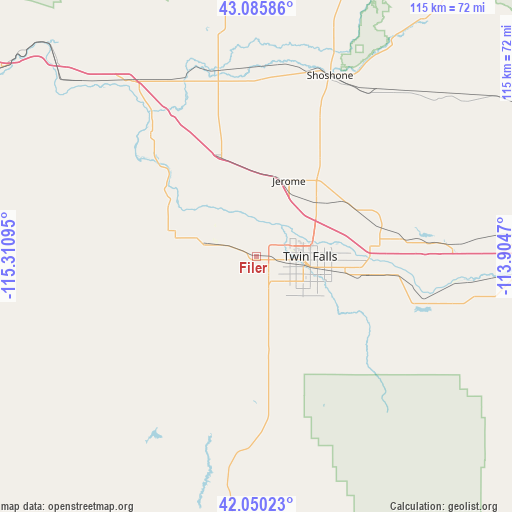
Filer GPS coordinates[2]
42° 34' 12.684" North, 114° 36' 28.152" West
| Map corner | latitude | longitude |
|---|---|---|
| Upper-left | 43.08586°, | -115.31095° |
| Center: | 42.57019°, | -114.60782° |
| Lower-right: | 42.05023°, | -113.9047° |
| Map W x H: | 115.2×115.2 km | = 71.6×71.6mi |
| max Lat: | 71.29058° ⇑19.7% North |
| Filer: | 42.57019° |
| min Lat: | ⇓80.3% South 19.06759° |
| min Long | Filer | max Long |
| -171.73463° | -114.60782° | -66.98998° |
| W 11.2%⇐ | ⇒88.8% E |
Elevation
Elevation of Filer is 1148 m = 3766 ft, and this is 853.2 m = 2799 ft above average elevation for this country.
| Max E: |
3189 m = 10463 ft | 5.7% |
| Filer | 1148 m 3766 ft | |
| Avg. | 294.8 m = 967 ft | |
Min E: |
-60 m = -197 ft | 94.3% |
See also: United States elevation on elevation.city.
Geographical zone
Filer is located in North temperate zone (between Tropic of Cancer and the Arctic Circle). Distance of this Northern Tropic circle is 2127.4 km =1321.9 mi to South.| Distance of | km | miles | from Filer |
|---|---|---|---|
| North Pole | 5273.7 | 3276.9 | to North |
| Arctic Circle | 2667.8 | 1657.7 | to North |
| Tropic Cancer | 2127.4 | 1321.9 | to South |
| Equator | 4733.4 | 2941.2 | to South |


Nearby cities:
15 places around Filer: (largest is in red/bold)
• Buhl
12.8 km =8 mi,  284°
284°
• Burley
66.9 km =41.6 mi,  93°
93°
• Gooding
41.9 km =26 mi,  348°
348°
• Hagerman
35.9 km =22.3 mi,  318°
318°
• Hansen
25.5 km =15.8 mi,  99°
99°
• Hazelton
38.7 km =24 mi, 85°
• Heyburn
69.1 km =42.9 mi, 91°
• Jackpot
65.5 km =40.7 mi,  184°
184°
• Jerome
18.6 km =11.6 mi,  23°
23°
• Kimberly
20.3 km =12.6 mi, 101°
• Oakley
69.8 km =43.4 mi,  121°
121°
• Paul
67.6 km =42 mi, 86°
• Shoshone
43.9 km =27.3 mi, 22°
• Twin Falls
12.1 km =7.5 mi, 93°
• Wendell
24.2 km =15 mi,  340°
340°
Sources, notices
• [Note1] Compared only with cities in United States existing in our database
• [Src1] Map data: © OpenStreetMap contributors (CC-BY-SA)
• [Src2] Other city data from geonames.org with taken over terms of usage.
• [Src3] Geographical zone / Annual Mean Temperature by Robert A. Rohde @ Wikipedia
