Hungry Horse geodata
Hungry Horse (Montana) is a populated place; located in United States in America/Denver (GMT-6) time zone. With population of 826 people, there are 17560 cities with bigger population in this country. Compared to other cities in United States, 99% of cities are located further ↓South; 88.5% of cities are located further →East and 93.1% of cities have lower elevation than Hungry Horse. Note1


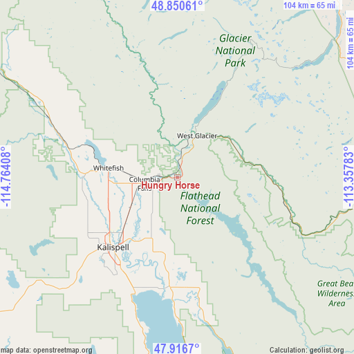
Hungry Horse GPS coordinates[2]
48° 23' 8.88" North, 114° 3' 39.42" West
| Map corner | latitude | longitude |
|---|---|---|
| Upper-left | 48.85061°, | -114.76408° |
| Center: | 48.3858°, | -114.06095° |
| Lower-right: | 47.9167°, | -113.35783° |
| Map W x H: | 103.8×103.8 km | = 64.5×64.5mi |
| max Lat: | 71.29058° ⇑1% North |
| Hungry Horse: | 48.3858° |
| min Lat: | ⇓99% South 19.06759° |
| min Long | Hungry Horse | max Long |
| -171.73463° | -114.06095° | -66.98998° |
| W 11.5%⇐ | ⇒88.5% E |
Elevation
Elevation of Hungry Horse is 945 m = 3100 ft, and this is 650.2 m = 2133 ft above average elevation for this country.
| Max E: |
3189 m = 10463 ft | 6.9% |
| Hungry Horse | 945 m 3100 ft | |
| Avg. | 294.8 m = 967 ft | |
Min E: |
-60 m = -197 ft | 93.1% |
See also: United States elevation on elevation.city.
Geographical zone
Hungry Horse is located in North temperate zone (between Tropic of Cancer and the Arctic Circle). Distance of this North polar circle is 2021.2 km =1255.9 mi to North.| Distance of | km | miles | from Hungry Horse |
|---|---|---|---|
| North Pole | 4627.1 | 2875.1 | to North |
| Arctic Circle | 2021.2 | 1255.9 | to North |
| Tropic Cancer | 2774.1 | 1723.7 | to South |
| Equator | 5380 | 3343 | to South |


Nearby cities:
15 places around Hungry Horse: (largest is in red/bold)
• Bigfork
35.9 km =22.3 mi,  181°
181°
• Browning
79.5 km =49.4 mi,  76°
76°
• Columbia Falls
9 km =5.6 mi,  260°
260°
• Coram
3.7 km =2.3 mi,  16°
16°
• Evergreen
23.9 km =14.9 mi,  221°
221°
• Kalispell
28.2 km =17.5 mi, 221°
• Lakeside
42.5 km =26.4 mi,  196°
196°
• Marion
54.4 km =33.8 mi,  235°
235°
• North Browning
80.2 km =49.8 mi, 75°
• Polson
77.3 km =48 mi,  185°
185°
• Somers
36 km =22.4 mi, 199°
• South Browning
79.2 km =49.2 mi, 76°
• Trego
69.3 km =43.1 mi,  300°
300°
• Whitefish
20.6 km =12.8 mi,  277°
277°
• Woods Bay
42.7 km =26.5 mi, 178°
Sources, notices
• [Note1] Compared only with cities in United States existing in our database
• [Src1] Map data: © OpenStreetMap contributors (CC-BY-SA)
• [Src2] Other city data from geonames.org with taken over terms of usage.
• [Src3] Geographical zone / Annual Mean Temperature by Robert A. Rohde @ Wikipedia
