Kalispell geodata
Kalispell (Montana) is a seat of a second-order administrative division; located in United States in America/Denver (GMT-6) time zone. With population of 22,052 people, there are 2298 cities with bigger population in this country. Compared to other cities in United States, 98.9% of cities are located further ↓South; 88.7% of cities are located further →East and 92.8% of cities have lower elevation than Kalispell. Note1


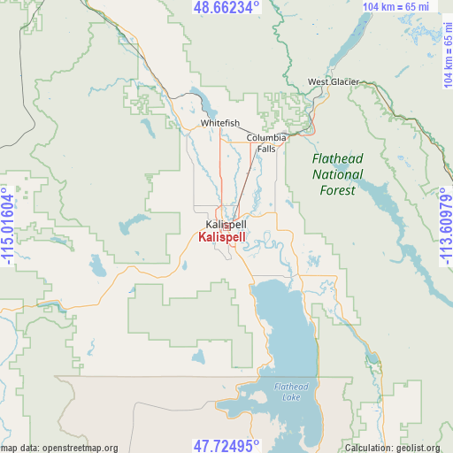
Kalispell GPS coordinates[2]
48° 11' 44.844" North, 114° 18' 46.476" West
| Map corner | latitude | longitude |
|---|---|---|
| Upper-left | 48.66234°, | -115.01604° |
| Center: | 48.19579°, | -114.31291° |
| Lower-right: | 47.72495°, | -113.60979° |
| Map W x H: | 104.2×104.2 km | = 64.7×64.7mi |
| max Lat: | 71.29058° ⇑1.1% North |
| Kalispell: | 48.19579° |
| min Lat: | ⇓98.9% South 19.06759° |
| min Long | Kalispell | max Long |
| -171.73463° | -114.31291° | -66.98998° |
| W 11.3%⇐ | ⇒88.7% E |
Elevation
Elevation of Kalispell is 904 m = 2966 ft, and this is 609.2 m = 1999 ft above average elevation for this country.
| Max E: |
3189 m = 10463 ft | 7.2% |
| Kalispell | 904 m 2966 ft | |
| Avg. | 294.8 m = 967 ft | |
Min E: |
-60 m = -197 ft | 92.8% |
See also: United States elevation on elevation.city.
Geographical zone
Kalispell is located in North temperate zone (between Tropic of Cancer and the Arctic Circle). Distance of this North polar circle is 2042.3 km =1269 mi to North.| Distance of | km | miles | from Kalispell |
|---|---|---|---|
| North Pole | 4648.2 | 2888.3 | to North |
| Arctic Circle | 2042.3 | 1269 | to North |
| Tropic Cancer | 2753 | 1710.6 | to South |
| Equator | 5358.9 | 3329.9 | to South |


Nearby cities:
15 places around Kalispell: (largest is in red/bold)
• Bigfork
23.1 km =14.4 mi,  129°
129°
• Columbia Falls
21.9 km =13.6 mi,  26°
26°
• Coram
31.6 km =19.6 mi,  38°
38°
• Evergreen
4.3 km =2.7 mi, 39°
• Hot Springs
70.4 km =43.7 mi,  202°
202°
• Hungry Horse
28.2 km =17.5 mi, 41°
• Lakeside
20.7 km =12.9 mi,  161°
161°
• Marion
27.9 km =17.3 mi,  248°
248°
• Pablo
67.8 km =42.1 mi,  167°
167°
• Polson
56.9 km =35.4 mi, 168°
• Ronan
75.8 km =47.1 mi, 167°
• Somers
14.5 km =9 mi,  152°
152°
• Trego
69.9 km =43.4 mi,  324°
324°
• Whitefish
24 km =14.9 mi,  355°
355°
• Woods Bay
29.1 km =18.1 mi,  137°
137°
Sources, notices
• [Note1] Compared only with cities in United States existing in our database
• [Src1] Map data: © OpenStreetMap contributors (CC-BY-SA)
• [Src2] Other city data from geonames.org with taken over terms of usage.
• [Src3] Geographical zone / Annual Mean Temperature by Robert A. Rohde @ Wikipedia
