Ashland geodata
Ashland (Oregon) is a populated place; located in United States in America/Los_Angeles (GMT-7) time zone. With population of 20,861 people, there are 2413 cities with bigger population in this country. Compared to other cities in United States, 77.3% of cities are located further ↓South; 97.2% of cities are located further →East and 89.6% of cities have lower elevation than Ashland. Note1


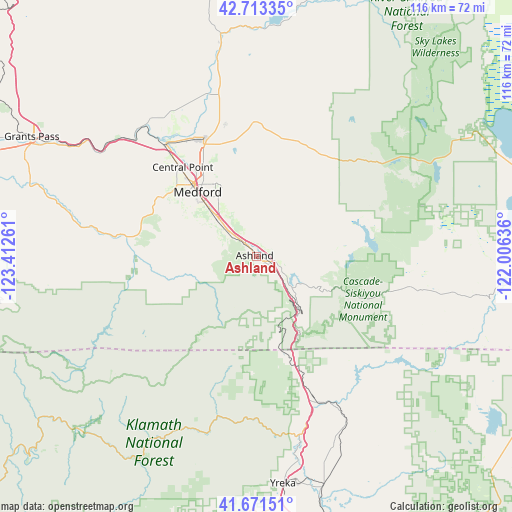
Ashland GPS coordinates[2]
42° 11' 40.488" North, 122° 42' 34.128" West
| Map corner | latitude | longitude |
|---|---|---|
| Upper-left | 42.71335°, | -123.41261° |
| Center: | 42.19458°, | -122.70948° |
| Lower-right: | 41.67151°, | -122.00636° |
| Map W x H: | 115.8×115.8 km | = 72×72mi |
| max Lat: | 71.29058° ⇑22.7% North |
| Ashland: | 42.19458° |
| min Lat: | ⇓77.3% South 19.06759° |
| min Long | Ashland | max Long |
| -171.73463° | -122.70948° | -66.98998° |
| W 2.8%⇐ | ⇒97.2% E |
Elevation
Elevation of Ashland is 597 m = 1959 ft, and this is 302.2 m = 991 ft above average elevation for this country.
| Max E: |
3189 m = 10463 ft | 10.4% |
| Ashland | 597 m 1959 ft | |
| Avg. | 294.8 m = 967 ft | |
Min E: |
-60 m = -197 ft | 89.6% |
See also: United States elevation on elevation.city.
Geographical zone
Ashland is located in North temperate zone (between Tropic of Cancer and the Arctic Circle). Distance of this Northern Tropic circle is 2085.7 km =1296 mi to South.| Distance of | km | miles | from Ashland |
|---|---|---|---|
| North Pole | 5315.5 | 3302.9 | to North |
| Arctic Circle | 2709.6 | 1683.7 | to North |
| Tropic Cancer | 2085.7 | 1296 | to South |
| Equator | 4691.6 | 2915.2 | to South |


Nearby cities:
15 places around Ashland: (largest is in red/bold)
• Central Point
26.4 km =16.4 mi,  319°
319°
• Eagle Point
31.9 km =19.8 mi,  346°
346°
• Foots Creek
42.4 km =26.3 mi,  303°
303°
• Gold Hill
38.5 km =23.9 mi,  313°
313°
• Jacksonville
25 km =15.5 mi, 301°
• Medford
20.1 km =12.5 mi, 317°
• Phoenix
12.7 km =7.9 mi, 315°
• Rogue River
46.5 km =28.9 mi, 305°
• Ruch
27.4 km =17 mi,  282°
282°
• Shady Cove
47 km =29.2 mi, 349°
• Talent
8.6 km =5.3 mi, 311°
• Trail
51.1 km =31.8 mi, 350°
• White City
29.7 km =18.5 mi,  335°
335°
• Williams
46.6 km =29 mi,  273°
273°
• Yreka
51.4 km =31.9 mi,  173°
173°
Sources, notices
• [Note1] Compared only with cities in United States existing in our database
• [Src1] Map data: © OpenStreetMap contributors (CC-BY-SA)
• [Src2] Other city data from geonames.org with taken over terms of usage.
• [Src3] Geographical zone / Annual Mean Temperature by Robert A. Rohde @ Wikipedia
