Medford geodata
Medford (Oregon) is a seat of a second-order administrative division; located in United States in America/Los_Angeles (GMT-7) time zone. With population of 79,805 people, there are 498 cities with bigger population in this country. Compared to other cities in United States, 78.4% of cities are located further ↓South; 97.6% of cities are located further →East and 84.9% of cities have lower elevation than Medford. Note1


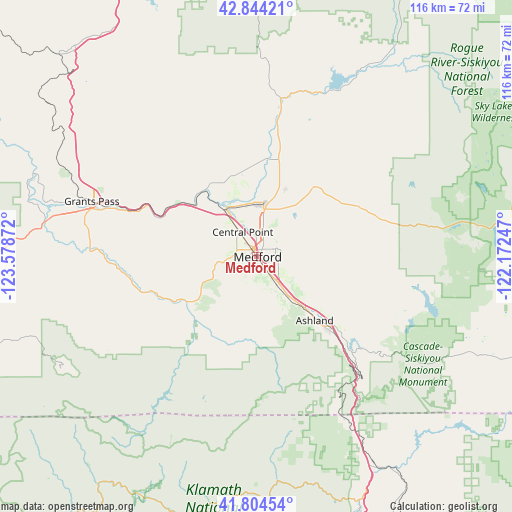
Medford GPS coordinates[2]
42° 19' 35.472" North, 122° 52' 32.124" West
| Map corner | latitude | longitude |
|---|---|---|
| Upper-left | 42.84421°, | -123.57872° |
| Center: | 42.32652°, | -122.87559° |
| Lower-right: | 41.80454°, | -122.17247° |
| Map W x H: | 115.6×115.6 km | = 71.8×71.8mi |
| max Lat: | 71.29058° ⇑21.6% North |
| Medford: | 42.32652° |
| min Lat: | ⇓78.4% South 19.06759° |
| min Long | Medford | max Long |
| -171.73463° | -122.87559° | -66.98998° |
| W 2.4%⇐ | ⇒97.6% E |
Elevation
Elevation of Medford is 422 m = 1385 ft, and this is 127.2 m = 417 ft above average elevation for this country.
| Max E: |
3189 m = 10463 ft | 15.1% |
| Medford | 422 m 1385 ft | |
| Avg. | 294.8 m = 967 ft | |
Min E: |
-60 m = -197 ft | 84.9% |
See also: Medford elevation on elevation.city.
Geographical zone
Medford is located in North temperate zone (between Tropic of Cancer and the Arctic Circle). Distance of this Northern Tropic circle is 2100.3 km =1305.1 mi to South.| Distance of | km | miles | from Medford |
|---|---|---|---|
| North Pole | 5300.8 | 3293.8 | to North |
| Arctic Circle | 2694.9 | 1674.5 | to North |
| Tropic Cancer | 2100.3 | 1305.1 | to South |
| Equator | 4706.3 | 2924.4 | to South |


Nearby cities:
15 places around Medford: (largest is in red/bold)
• Ashland
20.1 km =12.5 mi,  137°
137°
• Central Point
6.4 km =4 mi,  328°
328°
• Eagle Point
17.3 km =10.7 mi,  20°
20°
• Foots Creek
23.3 km =14.5 mi,  291°
291°
• Gold Hill
18.5 km =11.5 mi,  309°
309°
• Jacksonville
7.7 km =4.8 mi,  259°
259°
• Phoenix
7.4 km =4.6 mi, 140°
• Rogue River
27.2 km =16.9 mi,  296°
296°
• Ruch
15.8 km =9.8 mi,  235°
235°
• Shady Cove
32 km =19.9 mi,  9°
9°
• Talent
11.5 km =7.1 mi, 141°
• Trail
36.2 km =22.5 mi, 8°
• White City
12.4 km =7.7 mi, 6°
• Williams
34.9 km =21.7 mi,  249°
249°
• Wimer
32.6 km =20.3 mi,  316°
316°
Sources, notices
• [Note1] Compared only with cities in United States existing in our database
• [Src1] Map data: © OpenStreetMap contributors (CC-BY-SA)
• [Src2] Other city data from geonames.org with taken over terms of usage.
• [Src3] Geographical zone / Annual Mean Temperature by Robert A. Rohde @ Wikipedia
