Gearhart geodata
Gearhart (Oregon) is a populated place; located in United States in America/Los_Angeles (GMT-7) time zone. With population of 1,524 people, there are 13569 cities with bigger population in this country. Compared to other cities in United States, 95.1% of cities are located further ↓South; 98.5% of cities are located further →East and 97.4% of cities have higher elevation than Gearhart. Note1


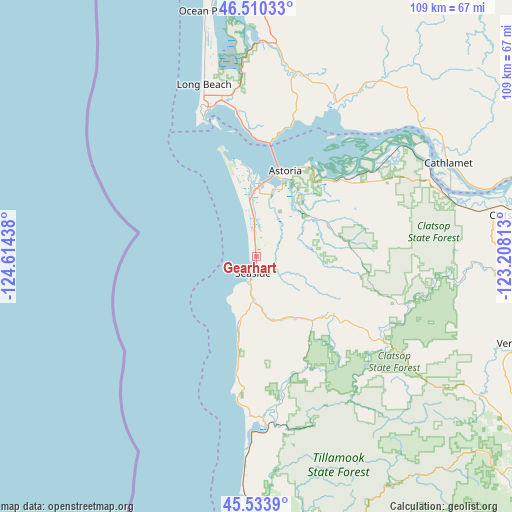
Gearhart GPS coordinates[2]
46° 1' 27.372" North, 123° 54' 40.5" West
| Map corner | latitude | longitude |
|---|---|---|
| Upper-left | 46.51033°, | -124.61438° |
| Center: | 46.02427°, | -123.91125° |
| Lower-right: | 45.5339°, | -123.20813° |
| Map W x H: | 108.6×108.6 km | = 67.5×67.5mi |
| max Lat: | 71.29058° ⇑4.9% North |
| Gearhart: | 46.02427° |
| min Lat: | ⇓95.1% South 19.06759° |
| min Long | Gearhart | max Long |
| -171.73463° | -123.91125° | -66.98998° |
| W 1.5%⇐ | ⇒98.5% E |
Elevation
Elevation of Gearhart is 6 m = 20 ft, and this is 288.8 m = 948 ft below average elevation for this country.
| Max E: |
3189 m = 10463 ft | 97.4% |
| Avg. | 294.8 m = 967 ft | |
| Gearhart | 6 m = 20 ft | |
Min E: |
-60 m = -197 ft | 2.6% |
See also: United States elevation on elevation.city.
Geographical zone
Gearhart is located in North temperate zone (between Tropic of Cancer and the Arctic Circle). Distance of this North polar circle is 2283.8 km =1419.1 mi to North.| Distance of | km | miles | from Gearhart |
|---|---|---|---|
| North Pole | 4889.6 | 3038.3 | to North |
| Arctic Circle | 2283.8 | 1419.1 | to North |
| Tropic Cancer | 2511.5 | 1560.6 | to South |
| Equator | 5117.4 | 3179.8 | to South |


Nearby cities:
15 places around Gearhart: (largest is in red/bold)
• Astoria
19.2 km =11.9 mi,  18°
18°
• Bay City
55.8 km =34.7 mi,  178°
178°
• Bayside Gardens
34.5 km =21.4 mi, 180°
• Cannon Beach
15.2 km =9.4 mi,  194°
194°
• Cathlamet
45.3 km =28.1 mi,  63°
63°
• Clatskanie
55 km =34.2 mi,  81°
81°
• Garibaldi
51.6 km =32.1 mi, 179°
• Hammond
19.8 km =12.3 mi,  350°
350°
• Ilwaco
33.2 km =20.6 mi,  342°
342°
• Long Beach
38.1 km =23.7 mi, 343°
• Manzanita
34.1 km =21.2 mi, 183°
• Ocean Park
53.1 km =33 mi, 348°
• Rockaway Beach
45.7 km =28.4 mi, 183°
• Seaside
3.6 km =2.2 mi, 194°
• Warrenton
15.7 km =9.8 mi,  356°
356°
Sources, notices
• [Note1] Compared only with cities in United States existing in our database
• [Src1] Map data: © OpenStreetMap contributors (CC-BY-SA)
• [Src2] Other city data from geonames.org with taken over terms of usage.
• [Src3] Geographical zone / Annual Mean Temperature by Robert A. Rohde @ Wikipedia
