Warrenton geodata
Warrenton (Oregon) is a populated place; located in United States in America/Los_Angeles (GMT-7) time zone. With population of 5,282 people, there are 6928 cities with bigger population in this country. Compared to other cities in United States, 95.3% of cities are located further ↓South; 98.5% of cities are located further →East and 99.4% of cities have higher elevation than Warrenton. Note1


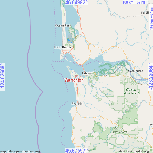
Warrenton GPS coordinates[2]
46° 9' 54.36" North, 123° 55' 25.536" West
| Map corner | latitude | longitude |
|---|---|---|
| Upper-left | 46.64992°, | -124.62689° |
| Center: | 46.1651°, | -123.92376° |
| Lower-right: | 45.67597°, | -123.22064° |
| Map W x H: | 108.3×108.3 km | = 67.3×67.3mi |
| max Lat: | 71.29058° ⇑4.7% North |
| Warrenton: | 46.1651° |
| min Lat: | ⇓95.3% South 19.06759° |
| min Long | Warrenton | max Long |
| -171.73463° | -123.92376° | -66.98998° |
| W 1.5%⇐ | ⇒98.5% E |
Elevation
Elevation of Warrenton is 2 m = 7 ft, and this is 292.8 m = 961 ft below average elevation for this country.
| Max E: |
3189 m = 10463 ft | 99.4% |
| Avg. | 294.8 m = 967 ft | |
| Warrenton | 2 m = 7 ft | |
Min E: |
-60 m = -197 ft | 0.6% |
See also: United States elevation on elevation.city.
Geographical zone
Warrenton is located in North temperate zone (between Tropic of Cancer and the Arctic Circle). Distance of this North polar circle is 2268.1 km =1409.3 mi to North.| Distance of | km | miles | from Warrenton |
|---|---|---|---|
| North Pole | 4874 | 3028.6 | to North |
| Arctic Circle | 2268.1 | 1409.3 | to North |
| Tropic Cancer | 2527.2 | 1570.3 | to South |
| Equator | 5133.1 | 3189.6 | to South |


Nearby cities:
15 places around Warrenton: (largest is in red/bold)
• Astoria
7.6 km =4.7 mi,  70°
70°
• Bayside Gardens
50.2 km =31.2 mi,  179°
179°
• Cannon Beach
30.5 km =19 mi,  185°
185°
• Cathlamet
41.8 km =26 mi,  84°
84°
• Clatskanie
55.7 km =34.6 mi,  97°
97°
• Gearhart
15.7 km =9.8 mi, 176°
• Hammond
4.4 km =2.7 mi,  331°
331°
• Ilwaco
18.4 km =11.4 mi, 330°
• Long Beach
23.1 km =14.4 mi, 334°
• Manzanita
49.7 km =30.9 mi, 181°
• Ocean Park
37.6 km =23.4 mi,  344°
344°
• Raymond
59.8 km =37.2 mi,  14°
14°
• Rockaway Beach
61.4 km =38.2 mi, 181°
• Seaside
19.1 km =11.9 mi, 179°
• South Bend
56.1 km =34.9 mi, 9°
Sources, notices
• [Note1] Compared only with cities in United States existing in our database
• [Src1] Map data: © OpenStreetMap contributors (CC-BY-SA)
• [Src2] Other city data from geonames.org with taken over terms of usage.
• [Src3] Geographical zone / Annual Mean Temperature by Robert A. Rohde @ Wikipedia
