Rainier geodata
Rainier (Oregon) is a populated place; located in United States in America/Los_Angeles (GMT-7) time zone. With population of 1,920 people, there are 12176 cities with bigger population in this country. Compared to other cities in United States, 95.2% of cities are located further ↓South; 97.7% of cities are located further →East and 90.5% of cities have higher elevation than Rainier. Note1


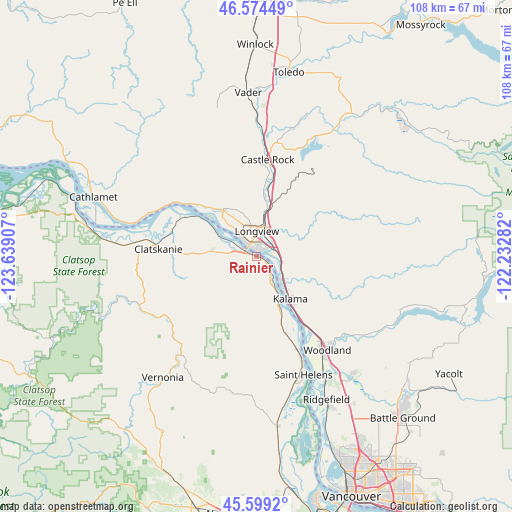
Rainier GPS coordinates[2]
46° 5' 20.4" North, 122° 56' 9.384" West
| Map corner | latitude | longitude |
|---|---|---|
| Upper-left | 46.57449°, | -123.63907° |
| Center: | 46.089°, | -122.93594° |
| Lower-right: | 45.5992°, | -122.23282° |
| Map W x H: | 108.4×108.4 km | = 67.4×67.4mi |
| max Lat: | 71.29058° ⇑4.8% North |
| Rainier: | 46.089° |
| min Lat: | ⇓95.2% South 19.06759° |
| min Long | Rainier | max Long |
| -171.73463° | -122.93594° | -66.98998° |
| W 2.3%⇐ | ⇒97.7% E |
Elevation
Elevation of Rainier is 15 m = 49 ft, and this is 279.8 m = 918 ft below average elevation for this country.
| Max E: |
3189 m = 10463 ft | 90.5% |
| Avg. | 294.8 m = 967 ft | |
| Rainier | 15 m = 49 ft | |
Min E: |
-60 m = -197 ft | 9.5% |
See also: United States elevation on elevation.city.
Geographical zone
Rainier is located in North temperate zone (between Tropic of Cancer and the Arctic Circle). Distance of this North polar circle is 2276.6 km =1414.6 mi to North.| Distance of | km | miles | from Rainier |
|---|---|---|---|
| North Pole | 4882.4 | 3033.8 | to North |
| Arctic Circle | 2276.6 | 1414.6 | to North |
| Tropic Cancer | 2518.7 | 1565 | to South |
| Equator | 5124.6 | 3184.3 | to South |


Nearby cities:
15 places around Rainier: (largest is in red/bold)
• Castle Rock
20.8 km =12.9 mi,  6°
6°
• Clatskanie
20.9 km =13 mi,  273°
273°
• Columbia City
24.3 km =15.1 mi,  155°
155°
• Kalama
11.4 km =7.1 mi,  141°
141°
• Kelso
6.8 km =4.2 mi,  18°
18°
• La Center
32.5 km =20.2 mi, 140°
• Longview
5.5 km =3.4 mi,  358°
358°
• Longview Heights
10.3 km =6.4 mi,  350°
350°
• Ridgefield
33.9 km =21.1 mi,  153°
153°
• Saint Helens
26.9 km =16.7 mi, 158°
• Vernonia
32.4 km =20.1 mi,  217°
217°
• Warren
30.8 km =19.1 mi,  167°
167°
• West Longview
10 km =6.2 mi,  331°
331°
• West Side Highway
10.7 km =6.6 mi, 7°
• Woodland
25.3 km =15.7 mi, 144°
Sources, notices
• [Note1] Compared only with cities in United States existing in our database
• [Src1] Map data: © OpenStreetMap contributors (CC-BY-SA)
• [Src2] Other city data from geonames.org with taken over terms of usage.
• [Src3] Geographical zone / Annual Mean Temperature by Robert A. Rohde @ Wikipedia
