Blackhawk geodata
Blackhawk (South Dakota) is a populated place; located in United States in America/Denver (GMT-6) time zone. With population of 2,892 people, there are 9818 cities with bigger population in this country. Compared to other cities in United States, 89% of cities are located further ↓South; 82.4% of cities are located further →East and 93.8% of cities have lower elevation than Blackhawk. Note1
Administrative division(s):
- Level 1: South Dakota
- Level 2: Meade County
- Level 3: Unorganized Territory of Southwest Meade


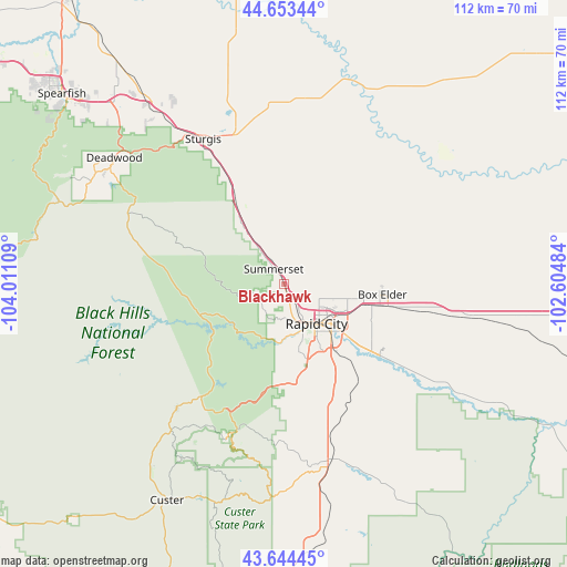
Blackhawk GPS coordinates[2]
44° 9' 3.96" North, 103° 18' 28.656" West
| Map corner | latitude | longitude |
|---|---|---|
| Upper-left | 44.65344°, | -104.01109° |
| Center: | 44.1511°, | -103.30796° |
| Lower-right: | 43.64445°, | -102.60484° |
| Map W x H: | 112.2×112.2 km | = 69.7×69.7mi |
| max Lat: | 71.29058° ⇑11% North |
| Blackhawk: | 44.1511° |
| min Lat: | ⇓89% South 19.06759° |
| min Long | Blackhawk | max Long |
| -171.73463° | -103.30796° | -66.98998° |
| W 17.6%⇐ | ⇒82.4% E |
Elevation
Elevation of Blackhawk is 1064 m = 3491 ft, and this is 769.2 m = 2524 ft above average elevation for this country.
| Max E: |
3189 m = 10463 ft | 6.2% |
| Blackhawk | 1064 m 3491 ft | |
| Avg. | 294.8 m = 967 ft | |
Min E: |
-60 m = -197 ft | 93.8% |
See also: United States elevation on elevation.city.
Geographical zone
Blackhawk is located in North temperate zone (between Tropic of Cancer and the Arctic Circle). Distance of this Northern Tropic circle is 2303.2 km =1431.1 mi to South.| Distance of | km | miles | from Blackhawk |
|---|---|---|---|
| North Pole | 5097.9 | 3167.7 | to North |
| Arctic Circle | 2492 | 1548.5 | to North |
| Tropic Cancer | 2303.2 | 1431.1 | to South |
| Equator | 4909.1 | 3050.4 | to South |


Nearby cities:
15 places around Blackhawk: (largest is in red/bold)
• Ashland Heights
14.8 km =9.2 mi,  99°
99°
• Box Elder
19.6 km =12.2 mi, 102°
• Colonial Pine Hills
15.9 km =9.9 mi,  182°
182°
• Deadwood
41.9 km =26 mi,  306°
306°
• Green Valley
20.3 km =12.6 mi,  129°
129°
• Hill City
32.4 km =20.1 mi,  221°
221°
• Johnson Siding
12.7 km =7.9 mi,  234°
234°
• Lead
42.7 km =26.5 mi,  301°
301°
• New Underwood
38.2 km =23.7 mi, 99°
• Piedmont
11 km =6.8 mi,  324°
324°
• Rapid City
10 km =6.2 mi,  141°
141°
• Rapid Valley
16.2 km =10.1 mi, 127°
• Sturgis
32.9 km =20.4 mi,  330°
330°
• Summerset
5.2 km =3.2 mi, 326°
• Whitewood
43.4 km =27 mi, 322°
Sources, notices
• [Note1] Compared only with cities in United States existing in our database
• [Src1] Map data: © OpenStreetMap contributors (CC-BY-SA)
• [Src2] Other city data from geonames.org with taken over terms of usage.
• [Src3] Geographical zone / Annual Mean Temperature by Robert A. Rohde @ Wikipedia
