Lead geodata
Lead (South Dakota) is a populated place; located in United States in America/Denver (GMT-6) time zone. With population of 2,999 people, there are 9639 cities with bigger population in this country. Compared to other cities in United States, 89.9% of cities are located further ↓South; 82.6% of cities are located further →East and 97.2% of cities have lower elevation than Lead. Note1


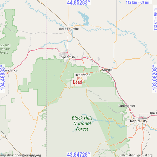
Lead GPS coordinates[2]
44° 21' 7.956" North, 103° 45' 54.72" West
| Map corner | latitude | longitude |
|---|---|---|
| Upper-left | 44.85283°, | -104.46833° |
| Center: | 44.35221°, | -103.7652° |
| Lower-right: | 43.84728°, | -103.06208° |
| Map W x H: | 111.8×111.8 km | = 69.5×69.5mi |
| max Lat: | 71.29058° ⇑10.1% North |
| Lead: | 44.35221° |
| min Lat: | ⇓89.9% South 19.06759° |
| min Long | Lead | max Long |
| -171.73463° | -103.7652° | -66.98998° |
| W 17.4%⇐ | ⇒82.6% E |
Elevation
Elevation of Lead is 1572 m = 5157 ft, and this is 1277.2 m = 4190 ft above average elevation for this country.
| Max E: |
3189 m = 10463 ft | 2.8% |
| Lead | 1572 m 5157 ft | |
| Avg. | 294.8 m = 967 ft | |
Min E: |
-60 m = -197 ft | 97.2% |
See also: United States elevation on elevation.city.
Geographical zone
Lead is located in North temperate zone (between Tropic of Cancer and the Arctic Circle). Distance of this Northern Tropic circle is 2325.6 km =1445.1 mi to South.| Distance of | km | miles | from Lead |
|---|---|---|---|
| North Pole | 5075.6 | 3153.8 | to North |
| Arctic Circle | 2469.7 | 1534.6 | to North |
| Tropic Cancer | 2325.6 | 1445.1 | to South |
| Equator | 4931.5 | 3064.3 | to South |


Nearby cities:
15 places around Lead: (largest is in red/bold)
• Belle Fourche
36.2 km =22.5 mi,  349°
349°
• Blackhawk
42.7 km =26.5 mi,  121°
121°
• Colonial Pine Hills
52.5 km =32.6 mi,  136°
136°
• Deadwood
3.9 km =2.4 mi,  46°
46°
• Hill City
49.1 km =30.5 mi,  162°
162°
• Johnson Siding
39.6 km =24.6 mi, 138°
• Newell
48.7 km =30.3 mi,  34°
34°
• North Spearfish
19.9 km =12.4 mi,  329°
329°
• Piedmont
32.8 km =20.4 mi,  114°
114°
• Rapid City
52.2 km =32.4 mi,  125°
125°
• Spearfish
17.1 km =10.6 mi, 334°
• Sturgis
21.3 km =13.2 mi,  72°
72°
• Summerset
38.1 km =23.7 mi, 118°
• Sundance
48.9 km =30.4 mi,  277°
277°
• Whitewood
15.7 km =9.8 mi,  39°
39°
Sources, notices
• [Note1] Compared only with cities in United States existing in our database
• [Src1] Map data: © OpenStreetMap contributors (CC-BY-SA)
• [Src2] Other city data from geonames.org with taken over terms of usage.
• [Src3] Geographical zone / Annual Mean Temperature by Robert A. Rohde @ Wikipedia
