Kaysville geodata
Kaysville (Utah) is a populated place; located in United States in America/Denver (GMT-6) time zone. With population of 30,472 people, there are 1642 cities with bigger population in this country. Compared to other cities in United States, 66.3% of cities are located further ↓South; 87.3% of cities are located further →East and 95.5% of cities have lower elevation than Kaysville. Note1


Kaysville GPS coordinates[2]
41° 2' 6.792" North, 111° 56' 18.78" West
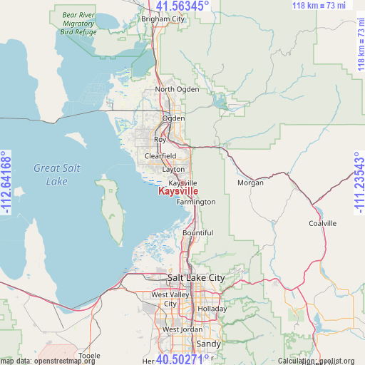
| Map corner | latitude | longitude |
|---|---|---|
| Upper-left | 41.56345°, | -112.64168° |
| Center: | 41.03522°, | -111.93855° |
| Lower-right: | 40.50271°, | -111.23543° |
| Map W x H: | 117.9×117.9 km | = 73.3×73.3mi |
| max Lat: | 71.29058° ⇑33.7% North |
| Kaysville: | 41.03522° |
| min Lat: | ⇓66.3% South 19.06759° |
| min Long | Kaysville | max Long |
| -171.73463° | -111.93855° | -66.98998° |
| W 12.7%⇐ | ⇒87.3% E |
Elevation
Elevation of Kaysville is 1332 m = 4370 ft, and this is 1037.2 m = 3403 ft above average elevation for this country.
| Max E: |
3189 m = 10463 ft | 4.5% |
| Kaysville | 1332 m 4370 ft | |
| Avg. | 294.8 m = 967 ft | |
Min E: |
-60 m = -197 ft | 95.5% |
See also: United States elevation on elevation.city.
Geographical zone
Kaysville is located in North temperate zone (between Tropic of Cancer and the Arctic Circle). Distance of this Northern Tropic circle is 1956.8 km =1215.9 mi to South.| Distance of | km | miles | from Kaysville |
|---|---|---|---|
| North Pole | 5444.4 | 3383 | to North |
| Arctic Circle | 2838.5 | 1763.8 | to North |
| Tropic Cancer | 1956.8 | 1215.9 | to South |
| Equator | 4562.7 | 2835.1 | to South |


Nearby cities:
15 places around Kaysville: (largest is in red/bold)
• Centerville
14.2 km =8.8 mi,  156°
156°
• Clearfield
11.2 km =7 mi,  318°
318°
• Clinton
14.9 km =9.3 mi, 321°
• Farmington
7.4 km =4.6 mi,  144°
144°
• Fruit Heights
3.1 km =1.9 mi,  96°
96°
• Hill Air Force Base
9 km =5.6 mi,  339°
339°
• Layton
3.9 km =2.4 mi, 315°
• Roy
15.9 km =9.9 mi,  332°
332°
• South Weber
10.8 km =6.7 mi,  3°
3°
• Sunset
13.7 km =8.5 mi, 325°
• Syracuse
12.2 km =7.6 mi,  299°
299°
• Uintah
12.2 km =7.6 mi,  6°
6°
• Washington Terrace
15.6 km =9.7 mi,  348°
348°
• West Bountiful
16 km =9.9 mi,  168°
168°
• West Point
15.3 km =9.5 mi,  307°
307°
Sources, notices
• [Note1] Compared only with cities in United States existing in our database
• [Src1] Map data: © OpenStreetMap contributors (CC-BY-SA)
• [Src2] Other city data from geonames.org with taken over terms of usage.
• [Src3] Geographical zone / Annual Mean Temperature by Robert A. Rohde @ Wikipedia
