Layton geodata
Layton (Utah) is a populated place; located in United States in America/Denver (GMT-6) time zone. With population of 74,143 people, there are 550 cities with bigger population in this country. Compared to other cities in United States, 66.5% of cities are located further ↓South; 87.4% of cities are located further →East and 95.4% of cities have lower elevation than Layton. Note1


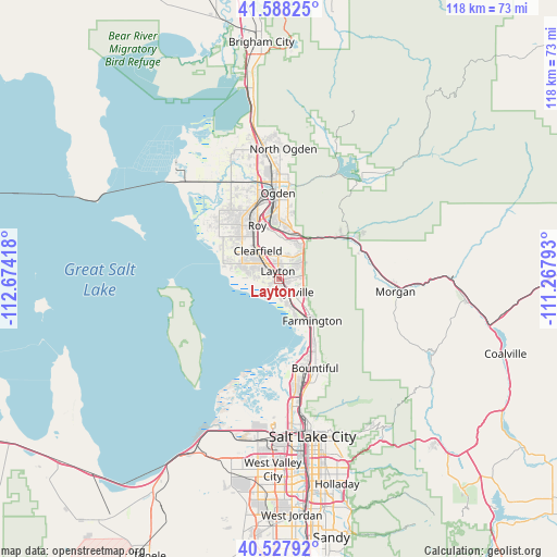
Layton GPS coordinates[2]
41° 3' 36.792" North, 111° 58' 15.78" West
| Map corner | latitude | longitude |
|---|---|---|
| Upper-left | 41.58825°, | -112.67418° |
| Center: | 41.06022°, | -111.97105° |
| Lower-right: | 40.52792°, | -111.26793° |
| Map W x H: | 117.9×117.9 km | = 73.3×73.3mi |
| max Lat: | 71.29058° ⇑33.5% North |
| Layton: | 41.06022° |
| min Lat: | ⇓66.5% South 19.06759° |
| min Long | Layton | max Long |
| -171.73463° | -111.97105° | -66.98998° |
| W 12.6%⇐ | ⇒87.4% E |
Elevation
Elevation of Layton is 1327 m = 4354 ft, and this is 1032.2 m = 3386 ft above average elevation for this country.
| Max E: |
3189 m = 10463 ft | 4.6% |
| Layton | 1327 m 4354 ft | |
| Avg. | 294.8 m = 967 ft | |
Min E: |
-60 m = -197 ft | 95.4% |
See also: Layton elevation on elevation.city.
Geographical zone
Layton is located in North temperate zone (between Tropic of Cancer and the Arctic Circle). Distance of this Northern Tropic circle is 1959.5 km =1217.6 mi to South.| Distance of | km | miles | from Layton |
|---|---|---|---|
| North Pole | 5441.6 | 3381.3 | to North |
| Arctic Circle | 2835.7 | 1762 | to North |
| Tropic Cancer | 1959.5 | 1217.6 | to South |
| Equator | 4565.5 | 2836.9 | to South |


Nearby cities:
15 places around Layton: (largest is in red/bold)
• Clearfield
7.3 km =4.5 mi,  320°
320°
• Clinton
11.1 km =6.9 mi, 322°
• Farmington
11.3 km =7 mi,  141°
141°
• Fruit Heights
6.6 km =4.1 mi,  118°
118°
• Hill Air Force Base
5.7 km =3.5 mi,  354°
354°
• Kaysville
3.9 km =2.4 mi, 135°
• Riverdale
13.3 km =8.3 mi, 348°
• Roy
12.2 km =7.6 mi,  337°
337°
• South Ogden
14.6 km =9.1 mi,  359°
359°
• South Weber
8.7 km =5.4 mi,  23°
23°
• Sunset
9.8 km =6.1 mi,  329°
329°
• Syracuse
8.5 km =5.3 mi,  292°
292°
• Uintah
10.2 km =6.3 mi, 23°
• Washington Terrace
12.5 km =7.8 mi, 357°
• West Point
11.5 km =7.1 mi,  304°
304°
Sources, notices
• [Note1] Compared only with cities in United States existing in our database
• [Src1] Map data: © OpenStreetMap contributors (CC-BY-SA)
• [Src2] Other city data from geonames.org with taken over terms of usage.
• [Src3] Geographical zone / Annual Mean Temperature by Robert A. Rohde @ Wikipedia
