Woods Cross geodata
Woods Cross (Utah) is a populated place; located in United States in America/Denver (GMT-6) time zone. With population of 11,284 people, there are 4091 cities with bigger population in this country. Compared to other cities in United States, 64.3% of cities are located further ↓South; 87.2% of cities are located further →East and 95.5% of cities have lower elevation than Woods Cross. Note1


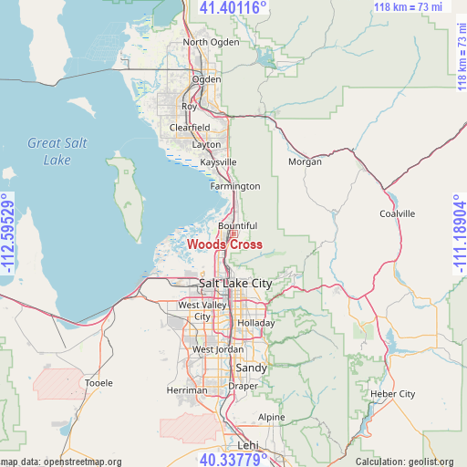
Woods Cross GPS coordinates[2]
40° 52' 17.796" North, 111° 53' 31.776" West
| Map corner | latitude | longitude |
|---|---|---|
| Upper-left | 41.40116°, | -112.59529° |
| Center: | 40.87161°, | -111.89216° |
| Lower-right: | 40.33779°, | -111.18904° |
| Map W x H: | 118.2×118.2 km | = 73.4×73.4mi |
| max Lat: | 71.29058° ⇑35.7% North |
| Woods Cross: | 40.87161° |
| min Lat: | ⇓64.3% South 19.06759° |
| min Long | Woods Cross | max Long |
| -171.73463° | -111.89216° | -66.98998° |
| W 12.8%⇐ | ⇒87.2% E |
Elevation
Elevation of Woods Cross is 1337 m = 4386 ft, and this is 1042.2 m = 3419 ft above average elevation for this country.
| Max E: |
3189 m = 10463 ft | 4.5% |
| Woods Cross | 1337 m 4386 ft | |
| Avg. | 294.8 m = 967 ft | |
Min E: |
-60 m = -197 ft | 95.5% |
See also: United States elevation on elevation.city.
Geographical zone
Woods Cross is located in North temperate zone (between Tropic of Cancer and the Arctic Circle). Distance of this Northern Tropic circle is 1938.6 km =1204.6 mi to South.| Distance of | km | miles | from Woods Cross |
|---|---|---|---|
| North Pole | 5462.6 | 3394.3 | to North |
| Arctic Circle | 2856.7 | 1775.1 | to North |
| Tropic Cancer | 1938.6 | 1204.6 | to South |
| Equator | 4544.5 | 2823.8 | to South |


Nearby cities:
15 places around Woods Cross: (largest is in red/bold)
• Bountiful
2.2 km =1.4 mi,  25°
25°
• Canyon Rim
19.3 km =12 mi,  162°
162°
• Centerfield
20.1 km =12.5 mi,  181°
181°
• Centerville
5.4 km =3.4 mi,  18°
18°
• East Millcreek
20.3 km =12.6 mi, 160°
• Farmington
12.1 km =7.5 mi,  1°
1°
• Fruit Heights
17.9 km =11.1 mi,  357°
357°
• Kaysville
18.6 km =11.6 mi,  347°
347°
• Millcreek
20.6 km =12.8 mi, 176°
• North Salt Lake
2.8 km =1.7 mi,  205°
205°
• Salt Lake City
12.3 km =7.6 mi, 179°
• South Salt Lake
17 km =10.6 mi, 178°
• West Bountiful
2.6 km =1.6 mi,  341°
341°
• West Valley City
22 km =13.7 mi,  204°
204°
• Willard
18.9 km =11.7 mi,  165°
165°
Sources, notices
• [Note1] Compared only with cities in United States existing in our database
• [Src1] Map data: © OpenStreetMap contributors (CC-BY-SA)
• [Src2] Other city data from geonames.org with taken over terms of usage.
• [Src3] Geographical zone / Annual Mean Temperature by Robert A. Rohde @ Wikipedia
