Camano geodata
Camano (Washington) is a populated place; located in United States in America/Los_Angeles (GMT-7) time zone. With population of 14,202 people, there are 3395 cities with bigger population in this country. Compared to other cities in United States, 98.8% of cities are located further ↓South; 96.7% of cities are located further →East and 89.5% of cities have higher elevation than Camano. Note1


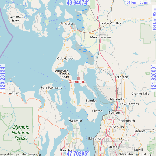
Camano GPS coordinates[2]
48° 10' 26.364" North, 122° 31' 41.556" West
| Map corner | latitude | longitude |
|---|---|---|
| Upper-left | 48.64074°, | -123.23134° |
| Center: | 48.17399°, | -122.52821° |
| Lower-right: | 47.70295°, | -121.82509° |
| Map W x H: | 104.3×104.3 km | = 64.8×64.8mi |
| max Lat: | 71.29058° ⇑1.2% North |
| Camano: | 48.17399° |
| min Lat: | ⇓98.8% South 19.06759° |
| min Long | Camano | max Long |
| -171.73463° | -122.52821° | -66.98998° |
| W 3.3%⇐ | ⇒96.7% E |
Elevation
Elevation of Camano is 17 m = 56 ft, and this is 277.8 m = 911 ft below average elevation for this country.
| Max E: |
3189 m = 10463 ft | 89.5% |
| Avg. | 294.8 m = 967 ft | |
| Camano | 17 m = 56 ft | |
Min E: |
-60 m = -197 ft | 10.5% |
See also: United States elevation on elevation.city.
Geographical zone
Camano is located in North temperate zone (between Tropic of Cancer and the Arctic Circle). Distance of this North polar circle is 2044.7 km =1270.5 mi to North.| Distance of | km | miles | from Camano |
|---|---|---|---|
| North Pole | 4650.6 | 2889.7 | to North |
| Arctic Circle | 2044.7 | 1270.5 | to North |
| Tropic Cancer | 2750.5 | 1709.1 | to South |
| Equator | 5356.4 | 3328.3 | to South |


Nearby cities:
15 places around Camano: (largest is in red/bold)
• Ault Field
21.2 km =13.2 mi,  329°
329°
• Cathan
19.8 km =12.3 mi,  109°
109°
• Coupeville
12.8 km =8 mi,  293°
293°
• Freeland
18.3 km =11.4 mi,  179°
179°
• John Sam Lake
22.1 km =13.7 mi, 108°
• Lake Ketchum
18.4 km =11.4 mi,  47°
47°
• Langley
17.4 km =10.8 mi,  148°
148°
• Marrowstone
18 km =11.2 mi,  221°
221°
• Oak Harbor
15.8 km =9.8 mi, 327°
• Port Townsend
18.4 km =11.4 mi,  249°
249°
• Stanwood
13.9 km =8.6 mi,  57°
57°
• Tulalip
21.1 km =13.1 mi,  123°
123°
• Tulalip Bay
22.2 km =13.8 mi,  133°
133°
• Warm Beach
12.1 km =7.5 mi,  91°
91°
• Weallup Lake
17.9 km =11.1 mi, 113°
Sources, notices
• [Note1] Compared only with cities in United States existing in our database
• [Src1] Map data: © OpenStreetMap contributors (CC-BY-SA)
• [Src2] Other city data from geonames.org with taken over terms of usage.
• [Src3] Geographical zone / Annual Mean Temperature by Robert A. Rohde @ Wikipedia
