Port Townsend geodata
Port Townsend (Washington) is a seat of a second-order administrative division; located in United States in America/Los_Angeles (GMT-7) time zone. With population of 9,335 people, there are 4676 cities with bigger population in this country. Compared to other cities in United States, 98.8% of cities are located further ↓South; 97.3% of cities are located further →East and 81.1% of cities have higher elevation than Port Townsend. Note1


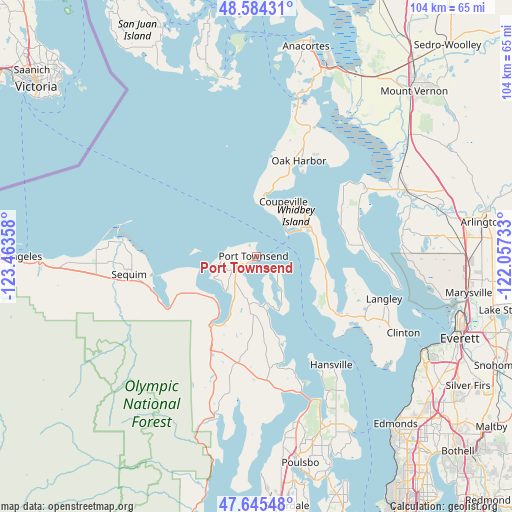
Port Townsend GPS coordinates[2]
48° 7' 1.344" North, 122° 45' 37.62" West
| Map corner | latitude | longitude |
|---|---|---|
| Upper-left | 48.58431°, | -123.46358° |
| Center: | 48.11704°, | -122.76045° |
| Lower-right: | 47.64548°, | -122.05733° |
| Map W x H: | 104.4×104.4 km | = 64.9×64.9mi |
| max Lat: | 71.29058° ⇑1.2% North |
| Port Townsend: | 48.11704° |
| min Lat: | ⇓98.8% South 19.06759° |
| min Long | Port Townsend | max Long |
| -171.73463° | -122.76045° | -66.98998° |
| W 2.7%⇐ | ⇒97.3% E |
Elevation
Elevation of Port Townsend is 42 m = 138 ft, and this is 252.8 m = 829 ft below average elevation for this country.
| Max E: |
3189 m = 10463 ft | 81.1% |
| Avg. | 294.8 m = 967 ft | |
| Port Townsend | 42 m = 138 ft | |
Min E: |
-60 m = -197 ft | 18.9% |
See also: United States elevation on elevation.city.
Geographical zone
Port Townsend is located in North temperate zone (between Tropic of Cancer and the Arctic Circle). Distance of this North polar circle is 2051.1 km =1274.5 mi to North.| Distance of | km | miles | from Port Townsend |
|---|---|---|---|
| North Pole | 4656.9 | 2893.7 | to North |
| Arctic Circle | 2051.1 | 1274.5 | to North |
| Tropic Cancer | 2744.2 | 1705.2 | to South |
| Equator | 5350.1 | 3324.4 | to South |


Nearby cities:
15 places around Port Townsend: (largest is in red/bold)
• Ault Field
25.4 km =15.8 mi,  14°
14°
• Bell Hill
25 km =15.5 mi,  254°
254°
• Camano
18.4 km =11.4 mi,  69°
69°
• Carlsborg
30.7 km =19.1 mi,  264°
264°
• Coupeville
12.7 km =7.9 mi,  25°
25°
• Freeland
21.1 km =13.1 mi,  124°
124°
• Hansville
26.9 km =16.7 mi,  145°
145°
• Langley
27.7 km =17.2 mi,  108°
108°
• Marrowstone
8.9 km =5.5 mi,  143°
143°
• Oak Harbor
21.4 km =13.3 mi,  23°
23°
• Port Hadlock-Irondale
9.6 km =6 mi,  191°
191°
• Port Ludlow
22.1 km =13.7 mi,  164°
164°
• Sequim
25.7 km =16 mi, 260°
• Stanwood
32 km =19.9 mi,  64°
64°
• Warm Beach
30 km =18.6 mi,  78°
78°
Sources, notices
• [Note1] Compared only with cities in United States existing in our database
• [Src1] Map data: © OpenStreetMap contributors (CC-BY-SA)
• [Src2] Other city data from geonames.org with taken over terms of usage.
• [Src3] Geographical zone / Annual Mean Temperature by Robert A. Rohde @ Wikipedia
