Canterwood geodata
Canterwood (Washington) is a populated place; located in United States in America/Los_Angeles (GMT-7) time zone. With population of 3,079 people, there are 9496 cities with bigger population in this country. Compared to other cities in United States, 97.3% of cities are located further ↓South; 96.9% of cities are located further →East and 68.6% of cities have higher elevation than Canterwood. Note1


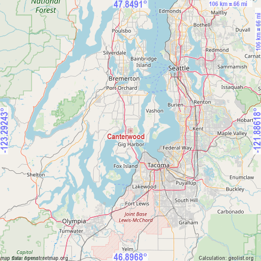
Canterwood GPS coordinates[2]
47° 22' 30.36" North, 122° 35' 21.48" West
| Map corner | latitude | longitude |
|---|---|---|
| Upper-left | 47.8491°, | -123.29243° |
| Center: | 47.3751°, | -122.5893° |
| Lower-right: | 46.8968°, | -121.88618° |
| Map W x H: | 105.9×105.9 km | = 65.8×65.8mi |
| max Lat: | 71.29058° ⇑2.7% North |
| Canterwood: | 47.3751° |
| min Lat: | ⇓97.3% South 19.06759° |
| min Long | Canterwood | max Long |
| -171.73463° | -122.5893° | -66.98998° |
| W 3.1%⇐ | ⇒96.9% E |
Elevation
Elevation of Canterwood is 109 m = 358 ft, and this is 185.8 m = 610 ft below average elevation for this country.
| Max E: |
3189 m = 10463 ft | 68.6% |
| Avg. | 294.8 m = 967 ft | |
| Canterwood | 109 m = 358 ft | |
Min E: |
-60 m = -197 ft | 31.4% |
See also: United States elevation on elevation.city.
Geographical zone
Canterwood is located in North temperate zone (between Tropic of Cancer and the Arctic Circle). Distance of this North polar circle is 2133.6 km =1325.8 mi to North.| Distance of | km | miles | from Canterwood |
|---|---|---|---|
| North Pole | 4739.4 | 2944.9 | to North |
| Arctic Circle | 2133.6 | 1325.8 | to North |
| Tropic Cancer | 2661.7 | 1653.9 | to South |
| Equator | 5267.6 | 3273.1 | to South |


Nearby cities:
15 places around Canterwood: (largest is in red/bold)
• Artondale
8.7 km =5.4 mi,  195°
195°
• Bethel
13.6 km =8.5 mi,  346°
346°
• Burley
5.7 km =3.5 mi,  326°
326°
• Dash Point
13.8 km =8.6 mi,  116°
116°
• Gig Harbor
5.1 km =3.2 mi,  172°
172°
• Key Center
12.4 km =7.7 mi,  251°
251°
• Klahanie
13.1 km =8.1 mi,  61°
61°
• Maplewood
3.8 km =2.4 mi,  39°
39°
• Purdy
3.1 km =1.9 mi,  299°
299°
• Rosedale
6.8 km =4.2 mi,  224°
224°
• Ruston
10.4 km =6.5 mi,  144°
144°
• Vashon
12.6 km =7.8 mi,  50°
50°
• Vaughn
13.5 km =8.4 mi,  255°
255°
• Wauna
4 km =2.5 mi,  276°
276°
• Wollochet
11.8 km =7.3 mi,  178°
178°
Sources, notices
• [Note1] Compared only with cities in United States existing in our database
• [Src1] Map data: © OpenStreetMap contributors (CC-BY-SA)
• [Src2] Other city data from geonames.org with taken over terms of usage.
• [Src3] Geographical zone / Annual Mean Temperature by Robert A. Rohde @ Wikipedia
