Fife Heights geodata
Fife Heights (Washington) is a populated place; located in United States in America/Los_Angeles (GMT-7) time zone. With population of 2,137 people, there are 11506 cities with bigger population in this country. Compared to other cities in United States, 97.1% of cities are located further ↓South; 96.2% of cities are located further →East and 65.5% of cities have higher elevation than Fife Heights. Note1


Fife Heights GPS coordinates[2]
47° 15' 32.364" North, 122° 20' 44.448" West
| Map corner | latitude | longitude |
|---|---|---|
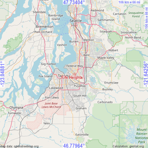
| Upper-left | 47.73404°, | -123.04881° |
| Center: | 47.25899°, | -122.34568° |
| Lower-right: | 46.77964°, | -121.64256° |
| Map W x H: | 106.1×106.1 km | = 65.9×65.9mi |
| max Lat: | 71.29058° ⇑2.9% North |
| Fife Heights: | 47.25899° |
| min Lat: | ⇓97.1% South 19.06759° |
| min Long | Fife Heights | max Long |
| -171.73463° | -122.34568° | -66.98998° |
| W 3.8%⇐ | ⇒96.2% E |
Elevation
Elevation of Fife Heights is 126 m = 413 ft, and this is 168.8 m = 554 ft below average elevation for this country.
| Max E: |
3189 m = 10463 ft | 65.5% |
| Avg. | 294.8 m = 967 ft | |
| Fife Heights | 126 m = 413 ft | |
Min E: |
-60 m = -197 ft | 34.5% |
See also: United States elevation on elevation.city.
Geographical zone
Fife Heights is located in North temperate zone (between Tropic of Cancer and the Arctic Circle). Distance of this North polar circle is 2146.5 km =1333.8 mi to North.| Distance of | km | miles | from Fife Heights |
|---|---|---|---|
| North Pole | 4752.4 | 2953 | to North |
| Arctic Circle | 2146.5 | 1333.8 | to North |
| Tropic Cancer | 2648.8 | 1645.9 | to South |
| Equator | 5254.7 | 3265.1 | to South |


Nearby cities:
15 places around Fife Heights: (largest is in red/bold)
• Algona
7.4 km =4.6 mi,  72°
72°
• Browns Point
8.6 km =5.3 mi,  302°
302°
• Dash Point
9 km =5.6 mi,  317°
317°
• Edgewood
4 km =2.5 mi,  104°
104°
• Federal Way
7.5 km =4.7 mi,  19°
19°
• Fife
2.4 km =1.5 mi,  201°
201°
• Lakeland North
9.8 km =6.1 mi,  32°
32°
• Lakeland South
5.2 km =3.2 mi, 65°
• Milton
2.8 km =1.7 mi,  115°
115°
• North Puyallup
7.5 km =4.7 mi,  140°
140°
• Pacific
7.2 km =4.5 mi,  85°
85°
• Puyallup
9.1 km =5.7 mi,  154°
154°
• Sumner
10.1 km =6.3 mi,  127°
127°
• Tacoma
7.5 km =4.7 mi,  264°
264°
• Waller
6.7 km =4.2 mi, 195°
Sources, notices
• [Note1] Compared only with cities in United States existing in our database
• [Src1] Map data: © OpenStreetMap contributors (CC-BY-SA)
• [Src2] Other city data from geonames.org with taken over terms of usage.
• [Src3] Geographical zone / Annual Mean Temperature by Robert A. Rohde @ Wikipedia
