Tacoma geodata
Tacoma (Washington) is a seat of a second-order administrative division; located in United States in America/Los_Angeles (GMT-7) time zone. With population of 207,948 people, there are 118 cities with bigger population in this country. Compared to other cities in United States, 97.1% of cities are located further ↓South; 96.4% of cities are located further →East and 74.6% of cities have higher elevation than Tacoma. Note1


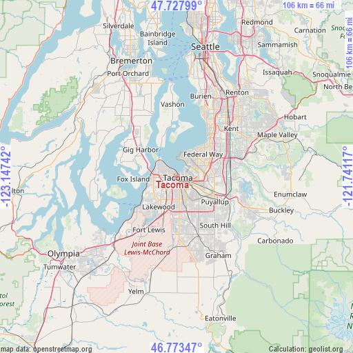
Tacoma GPS coordinates[2]
47° 15' 10.368" North, 122° 26' 39.444" West
| Map corner | latitude | longitude |
|---|---|---|
| Upper-left | 47.72799°, | -123.14742° |
| Center: | 47.25288°, | -122.44429° |
| Lower-right: | 46.77347°, | -121.74117° |
| Map W x H: | 106.1×106.1 km | = 65.9×65.9mi |
| max Lat: | 71.29058° ⇑2.9% North |
| Tacoma: | 47.25288° |
| min Lat: | ⇓97.1% South 19.06759° |
| min Long | Tacoma | max Long |
| -171.73463° | -122.44429° | -66.98998° |
| W 3.6%⇐ | ⇒96.4% E |
Elevation
Elevation of Tacoma is 74 m = 243 ft, and this is 220.8 m = 724 ft below average elevation for this country.
| Max E: |
3189 m = 10463 ft | 74.6% |
| Avg. | 294.8 m = 967 ft | |
| Tacoma | 74 m = 243 ft | |
Min E: |
-60 m = -197 ft | 25.4% |
See also: Tacoma elevation on elevation.city.
Geographical zone
Tacoma is located in North temperate zone (between Tropic of Cancer and the Arctic Circle). Distance of this North polar circle is 2147.1 km =1334.1 mi to North.| Distance of | km | miles | from Tacoma |
|---|---|---|---|
| North Pole | 4753 | 2953.4 | to North |
| Arctic Circle | 2147.1 | 1334.1 | to North |
| Tropic Cancer | 2648.1 | 1645.5 | to South |
| Equator | 5254 | 3264.7 | to South |


Nearby cities:
15 places around Tacoma: (largest is in red/bold)
• Browns Point
5.3 km =3.3 mi,  2°
2°
• Dash Point
7.5 km =4.7 mi,  10°
10°
• Edgewood
11.4 km =7.1 mi,  91°
91°
• Fife
6.8 km =4.2 mi,  102°
102°
• Fife Heights
7.5 km =4.7 mi,  84°
84°
• Fircrest
5.6 km =3.5 mi,  254°
254°
• Lakeview
11.2 km =7 mi,  201°
201°
• Lakewood
10.6 km =6.6 mi,  211°
211°
• Midland
10 km =6.2 mi,  162°
162°
• Milton
9.9 km =6.2 mi, 93°
• Parkland
10.9 km =6.8 mi,  175°
175°
• Ruston
7.1 km =4.4 mi,  316°
316°
• University Place
8.2 km =5.1 mi,  256°
256°
• Waller
8.1 km =5 mi,  135°
135°
• Wollochet
10.7 km =6.6 mi,  279°
279°
Sources, notices
• [Note1] Compared only with cities in United States existing in our database
• [Src1] Map data: © OpenStreetMap contributors (CC-BY-SA)
• [Src2] Other city data from geonames.org with taken over terms of usage.
• [Src3] Geographical zone / Annual Mean Temperature by Robert A. Rohde @ Wikipedia
