Indianola geodata
Indianola (Washington) is a populated place; located in United States in America/Los_Angeles (GMT-7) time zone. With population of 3,500 people, there are 8852 cities with bigger population in this country. Compared to other cities in United States, 98.2% of cities are located further ↓South; 96.7% of cities are located further →East and 95.7% of cities have higher elevation than Indianola. Note1


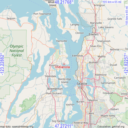
Indianola GPS coordinates[2]
47° 44' 49.344" North, 122° 31' 32.484" West
| Map corner | latitude | longitude |
|---|---|---|
| Upper-left | 48.21768°, | -123.22882° |
| Center: | 47.74704°, | -122.52569° |
| Lower-right: | 47.27211°, | -121.82257° |
| Map W x H: | 105.1×105.1 km | = 65.3×65.3mi |
| max Lat: | 71.29058° ⇑1.8% North |
| Indianola: | 47.74704° |
| min Lat: | ⇓98.2% South 19.06759° |
| min Long | Indianola | max Long |
| -171.73463° | -122.52569° | -66.98998° |
| W 3.3%⇐ | ⇒96.7% E |
Elevation
Elevation of Indianola is 8 m = 26 ft, and this is 286.8 m = 941 ft below average elevation for this country.
| Max E: |
3189 m = 10463 ft | 95.7% |
| Avg. | 294.8 m = 967 ft | |
| Indianola | 8 m = 26 ft | |
Min E: |
-60 m = -197 ft | 4.3% |
See also: United States elevation on elevation.city.
Geographical zone
Indianola is located in North temperate zone (between Tropic of Cancer and the Arctic Circle). Distance of this North polar circle is 2092.2 km =1300 mi to North.| Distance of | km | miles | from Indianola |
|---|---|---|---|
| North Pole | 4698.1 | 2919.3 | to North |
| Arctic Circle | 2092.2 | 1300 | to North |
| Tropic Cancer | 2703.1 | 1679.6 | to South |
| Equator | 5309 | 3298.9 | to South |


Nearby cities:
15 places around Indianola: (largest is in red/bold)
• Bainbridge Island
13.4 km =8.3 mi,  178°
178°
• Bangor Trident Base
14.4 km =8.9 mi,  259°
259°
• Edmonds
13.1 km =8.1 mi,  57°
57°
• Esperance
13.6 km =8.5 mi,  69°
69°
• Keyport
8.7 km =5.4 mi,  234°
234°
• Kingston
6.1 km =3.8 mi,  19°
19°
• Lofall
12.3 km =7.6 mi,  306°
306°
• Lynnwood
17.7 km =11 mi, 62°
• Mountlake Terrace
16.8 km =10.4 mi, 74°
• Poulsbo
9.1 km =5.7 mi, 262°
• Shoreline
13.8 km =8.6 mi,  86°
86°
• Silverdale
17 km =10.6 mi, 228°
• Suquamish
2.7 km =1.7 mi, 228°
• Tracyton
18.2 km =11.3 mi,  212°
212°
• Woodway
12 km =7.5 mi, 62°
Sources, notices
• [Note1] Compared only with cities in United States existing in our database
• [Src1] Map data: © OpenStreetMap contributors (CC-BY-SA)
• [Src2] Other city data from geonames.org with taken over terms of usage.
• [Src3] Geographical zone / Annual Mean Temperature by Robert A. Rohde @ Wikipedia
