Shoreline geodata
Shoreline (Washington) is a populated place; located in United States in America/Los_Angeles (GMT-7) time zone. With population of 55,439 people, there are 830 cities with bigger population in this country. Compared to other cities in United States, 98.2% of cities are located further ↓South; 96.2% of cities are located further →East and 61.7% of cities have higher elevation than Shoreline. Note1


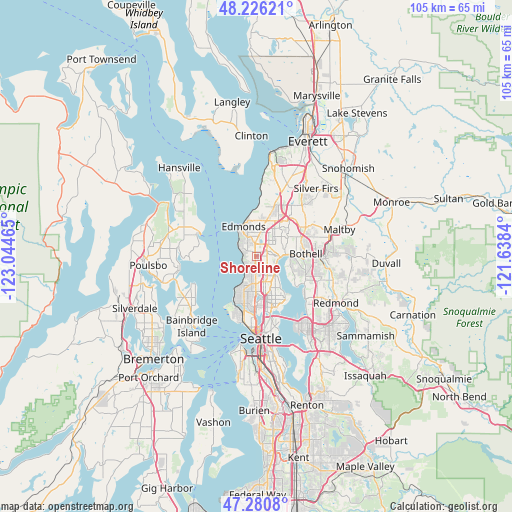
Shoreline GPS coordinates[2]
47° 45' 20.34" North, 122° 20' 29.472" West
| Map corner | latitude | longitude |
|---|---|---|
| Upper-left | 48.22621°, | -123.04465° |
| Center: | 47.75565°, | -122.34152° |
| Lower-right: | 47.2808°, | -121.6384° |
| Map W x H: | 105.1×105.1 km | = 65.3×65.3mi |
| max Lat: | 71.29058° ⇑1.8% North |
| Shoreline: | 47.75565° |
| min Lat: | ⇓98.2% South 19.06759° |
| min Long | Shoreline | max Long |
| -171.73463° | -122.34152° | -66.98998° |
| W 3.8%⇐ | ⇒96.2% E |
Elevation
Elevation of Shoreline is 146 m = 479 ft, and this is 148.8 m = 488 ft below average elevation for this country.
| Max E: |
3189 m = 10463 ft | 61.7% |
| Avg. | 294.8 m = 967 ft | |
| Shoreline | 146 m = 479 ft | |
Min E: |
-60 m = -197 ft | 38.3% |
See also: Shoreline elevation on elevation.city.
Geographical zone
Shoreline is located in North temperate zone (between Tropic of Cancer and the Arctic Circle). Distance of this North polar circle is 2091.2 km =1299.4 mi to North.| Distance of | km | miles | from Shoreline |
|---|---|---|---|
| North Pole | 4697.1 | 2918.6 | to North |
| Arctic Circle | 2091.2 | 1299.4 | to North |
| Tropic Cancer | 2704 | 1680.2 | to South |
| Equator | 5309.9 | 3299.4 | to South |


Nearby cities:
15 places around Shoreline: (largest is in red/bold)
• Alderwood Manor
8.6 km =5.3 mi,  31°
31°
• Bothell
10.2 km =6.3 mi,  85°
85°
• Bothell West
9.3 km =5.8 mi,  53°
53°
• Brier
6 km =3.7 mi,  57°
57°
• Edmonds
6.7 km =4.2 mi,  336°
336°
• Esperance
3.8 km =2.4 mi, 344°
• Inglewood-Finn Hill
9.1 km =5.7 mi,  115°
115°
• Kenmore
7.3 km =4.5 mi, 88°
• Lake Forest Park
4.5 km =2.8 mi, 88°
• Larch Way
11.8 km =7.3 mi, 34°
• Lynnwood
7.5 km =4.7 mi,  15°
15°
• Meadowdale
10.8 km =6.7 mi,  3°
3°
• Mountlake Terrace
4.4 km =2.7 mi, 34°
• Picnic Point-North Lynnwood
12.4 km =7.7 mi, 16°
• Woodway
5.5 km =3.4 mi,  325°
325°
Sources, notices
• [Note1] Compared only with cities in United States existing in our database
• [Src1] Map data: © OpenStreetMap contributors (CC-BY-SA)
• [Src2] Other city data from geonames.org with taken over terms of usage.
• [Src3] Geographical zone / Annual Mean Temperature by Robert A. Rohde @ Wikipedia
