Lakewood geodata
Lakewood (Washington) is a populated place; located in United States in America/Los_Angeles (GMT-7) time zone. With population of 59,829 people, there are 752 cities with bigger population in this country. Compared to other cities in United States, 96.9% of cities are located further ↓South; 96.6% of cities are located further →East and 73.9% of cities have higher elevation than Lakewood. Note1


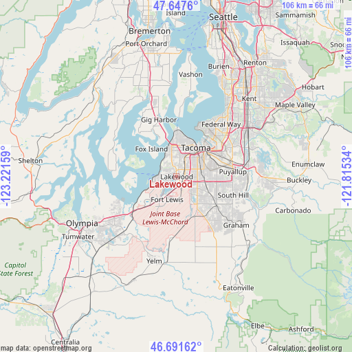
Lakewood GPS coordinates[2]
47° 10' 18.336" North, 122° 31' 6.456" West
| Map corner | latitude | longitude |
|---|---|---|
| Upper-left | 47.6476°, | -123.22159° |
| Center: | 47.17176°, | -122.51846° |
| Lower-right: | 46.69162°, | -121.81534° |
| Map W x H: | 106.3×106.3 km | = 66.1×66.1mi |
| max Lat: | 71.29058° ⇑3.1% North |
| Lakewood: | 47.17176° |
| min Lat: | ⇓96.9% South 19.06759° |
| min Long | Lakewood | max Long |
| -171.73463° | -122.51846° | -66.98998° |
| W 3.4%⇐ | ⇒96.6% E |
Elevation
Elevation of Lakewood is 78 m = 256 ft, and this is 216.8 m = 711 ft below average elevation for this country.
| Max E: |
3189 m = 10463 ft | 73.9% |
| Avg. | 294.8 m = 967 ft | |
| Lakewood | 78 m = 256 ft | |
Min E: |
-60 m = -197 ft | 26.1% |
See also: Lakewood elevation on elevation.city.
Geographical zone
Lakewood is located in North temperate zone (between Tropic of Cancer and the Arctic Circle). Distance of this North polar circle is 2156.2 km =1339.8 mi to North.| Distance of | km | miles | from Lakewood |
|---|---|---|---|
| North Pole | 4762.1 | 2959 | to North |
| Arctic Circle | 2156.2 | 1339.8 | to North |
| Tropic Cancer | 2639.1 | 1639.9 | to South |
| Equator | 5245 | 3259.1 | to South |


Nearby cities:
15 places around Lakewood: (largest is in red/bold)
• DuPont
11.9 km =7.4 mi,  225°
225°
• Fircrest
7.5 km =4.7 mi,  1°
1°
• Fox Island
12.2 km =7.6 mi,  316°
316°
• Joint Base Lewis McChord
8.4 km =5.2 mi,  211°
211°
• Lakeview
2.1 km =1.3 mi,  132°
132°
• McChord Air Force Base
4.7 km =2.9 mi,  154°
154°
• Midland
8.6 km =5.3 mi,  93°
93°
• North Fort Lewis
8 km =5 mi, 225°
• Parkland
6.6 km =4.1 mi,  105°
105°
• Spanaway
9.9 km =6.2 mi,  139°
139°
• Steilacoom
6.4 km =4 mi,  268°
268°
• Tacoma
10.6 km =6.6 mi,  31°
31°
• University Place
7.5 km =4.7 mi,  341°
341°
• Waller
11.7 km =7.3 mi,  74°
74°
• Wollochet
11.9 km =7.4 mi, 335°
Sources, notices
• [Note1] Compared only with cities in United States existing in our database
• [Src1] Map data: © OpenStreetMap contributors (CC-BY-SA)
• [Src2] Other city data from geonames.org with taken over terms of usage.
• [Src3] Geographical zone / Annual Mean Temperature by Robert A. Rohde @ Wikipedia
