Pe Ell geodata
Pe Ell (Washington) is a populated place; located in United States in America/Los_Angeles (GMT-7) time zone. With population of 634 people, there are 19318 cities with bigger population in this country. Compared to other cities in United States, 95.9% of cities are located further ↓South; 98.2% of cities are located further →East and 65.2% of cities have higher elevation than Pe Ell. Note1


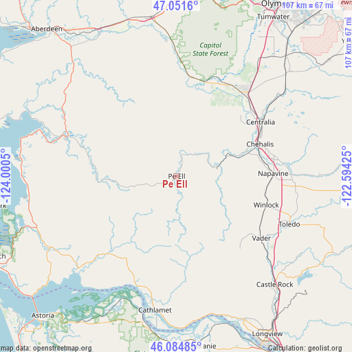
Pe Ell GPS coordinates[2]
46° 34' 13.368" North, 123° 17' 50.532" West
| Map corner | latitude | longitude |
|---|---|---|
| Upper-left | 47.0516°, | -124.0005° |
| Center: | 46.57038°, | -123.29737° |
| Lower-right: | 46.08485°, | -122.59425° |
| Map W x H: | 107.5×107.5 km | = 66.8×66.8mi |
| max Lat: | 71.29058° ⇑4.1% North |
| Pe Ell: | 46.57038° |
| min Lat: | ⇓95.9% South 19.06759° |
| min Long | Pe Ell | max Long |
| -171.73463° | -123.29737° | -66.98998° |
| W 1.8%⇐ | ⇒98.2% E |
Elevation
Elevation of Pe Ell is 127 m = 417 ft, and this is 167.8 m = 551 ft below average elevation for this country.
| Max E: |
3189 m = 10463 ft | 65.2% |
| Avg. | 294.8 m = 967 ft | |
| Pe Ell | 127 m = 417 ft | |
Min E: |
-60 m = -197 ft | 34.8% |
See also: United States elevation on elevation.city.
Geographical zone
Pe Ell is located in North temperate zone (between Tropic of Cancer and the Arctic Circle). Distance of this North polar circle is 2223 km =1381.3 mi to North.| Distance of | km | miles | from Pe Ell |
|---|---|---|---|
| North Pole | 4828.9 | 3000.5 | to North |
| Arctic Circle | 2223 | 1381.3 | to North |
| Tropic Cancer | 2572.2 | 1598.3 | to South |
| Equator | 5178.1 | 3217.5 | to South |


Nearby cities:
15 places around Pe Ell: (largest is in red/bold)
• Bucoda
41.3 km =25.7 mi,  52°
52°
• Cathlamet
41.4 km =25.7 mi,  189°
189°
• Centralia
30.8 km =19.1 mi,  58°
58°
• Chehalis
27.4 km =17 mi,  68°
68°
• Fords Prairie
29.8 km =18.5 mi, 52°
• Grand Mound
32.6 km =20.3 mi,  42°
42°
• Napavine
29.8 km =18.5 mi,  89°
89°
• Oakville
30.4 km =18.9 mi,  9°
9°
• Onalaska
44.3 km =27.5 mi, 89°
• Raymond
35.7 km =22.2 mi,  291°
291°
• Rochester
31.9 km =19.8 mi,  28°
28°
• South Bend
40.1 km =24.9 mi,  284°
284°
• Toledo
37.4 km =23.2 mi,  112°
112°
• Vader
31.8 km =19.8 mi,  125°
125°
• Winlock
28.9 km =18 mi, 107°
Sources, notices
• [Note1] Compared only with cities in United States existing in our database
• [Src1] Map data: © OpenStreetMap contributors (CC-BY-SA)
• [Src2] Other city data from geonames.org with taken over terms of usage.
• [Src3] Geographical zone / Annual Mean Temperature by Robert A. Rohde @ Wikipedia
