Fords Prairie geodata
Fords Prairie (Washington) is a populated place; located in United States in America/Los_Angeles (GMT-7) time zone. With population of 1,959 people, there are 12058 cities with bigger population in this country. Compared to other cities in United States, 96.2% of cities are located further ↓South; 97.8% of cities are located further →East and 78.6% of cities have higher elevation than Fords Prairie. Note1


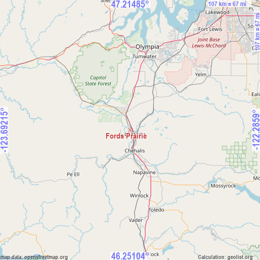
Fords Prairie GPS coordinates[2]
46° 44' 6.36" North, 122° 59' 20.472" West
| Map corner | latitude | longitude |
|---|---|---|
| Upper-left | 47.21485°, | -123.69215° |
| Center: | 46.7351°, | -122.98902° |
| Lower-right: | 46.25104°, | -122.2859° |
| Map W x H: | 107.2×107.2 km | = 66.6×66.6mi |
| max Lat: | 71.29058° ⇑3.8% North |
| Fords Prairie: | 46.7351° |
| min Lat: | ⇓96.2% South 19.06759° |
| min Long | Fords Prairie | max Long |
| -171.73463° | -122.98902° | -66.98998° |
| W 2.2%⇐ | ⇒97.8% E |
Elevation
Elevation of Fords Prairie is 53 m = 174 ft, and this is 241.8 m = 793 ft below average elevation for this country.
| Max E: |
3189 m = 10463 ft | 78.6% |
| Avg. | 294.8 m = 967 ft | |
| Fords Prairie | 53 m = 174 ft | |
Min E: |
-60 m = -197 ft | 21.4% |
See also: United States elevation on elevation.city.
Geographical zone
Fords Prairie is located in North temperate zone (between Tropic of Cancer and the Arctic Circle). Distance of this North polar circle is 2204.7 km =1369.9 mi to North.| Distance of | km | miles | from Fords Prairie |
|---|---|---|---|
| North Pole | 4810.6 | 2989.2 | to North |
| Arctic Circle | 2204.7 | 1369.9 | to North |
| Tropic Cancer | 2590.5 | 1609.7 | to South |
| Equator | 5196.5 | 3229 | to South |


Nearby cities:
15 places around Fords Prairie: (largest is in red/bold)
• Bucoda
11.5 km =7.1 mi,  51°
51°
• Centralia
3.4 km =2.1 mi,  128°
128°
• Chehalis
8.3 km =5.2 mi,  166°
166°
• Grand Mound
6.1 km =3.8 mi,  343°
343°
• Napavine
18.9 km =11.7 mi,  160°
160°
• Oakville
21.9 km =13.6 mi,  302°
302°
• Olympia
34.3 km =21.3 mi,  11°
11°
• Onalaska
27.3 km =17 mi, 130°
• Pe Ell
29.8 km =18.5 mi,  232°
232°
• Rainier
28.5 km =17.7 mi, 53°
• Rochester
12.6 km =7.8 mi,  319°
319°
• Tenino
17 km =10.6 mi,  37°
37°
• Toledo
34.6 km =21.5 mi, 161°
• Tumwater
30.9 km =19.2 mi, 11°
• Winlock
27.4 km =17 mi, 171°
Sources, notices
• [Note1] Compared only with cities in United States existing in our database
• [Src1] Map data: © OpenStreetMap contributors (CC-BY-SA)
• [Src2] Other city data from geonames.org with taken over terms of usage.
• [Src3] Geographical zone / Annual Mean Temperature by Robert A. Rohde @ Wikipedia
