Jackson geodata
Jackson (Wyoming) is a seat of a second-order administrative division; located in United States in America/Denver (GMT-6) time zone. With population of 10,523 people, there are 4317 cities with bigger population in this country. Compared to other cities in United States, 86.3% of cities are located further ↓South; 86.1% of cities are located further →East and 98.8% of cities have lower elevation than Jackson. Note1


Jackson GPS coordinates[2]
43° 28' 47.748" North, 110° 45' 44.748" West
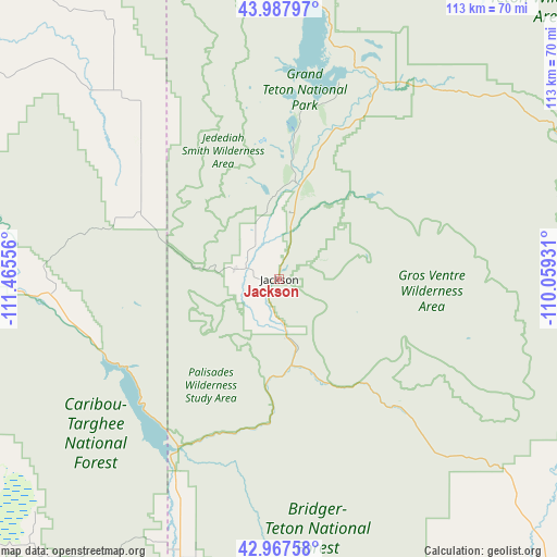
| Map corner | latitude | longitude |
|---|---|---|
| Upper-left | 43.98797°, | -111.46556° |
| Center: | 43.47993°, | -110.76243° |
| Lower-right: | 42.96758°, | -110.05931° |
| Map W x H: | 113.5×113.5 km | = 70.5×70.5mi |
| max Lat: | 71.29058° ⇑13.7% North |
| Jackson: | 43.47993° |
| min Lat: | ⇓86.3% South 19.06759° |
| min Long | Jackson | max Long |
| -171.73463° | -110.76243° | -66.98998° |
| W 13.9%⇐ | ⇒86.1% E |
Elevation
Elevation of Jackson is 1904 m = 6247 ft, and this is 1609.2 m = 5280 ft above average elevation for this country.
| Max E: |
3189 m = 10463 ft | 1.2% |
| Jackson | 1904 m 6247 ft | |
| Avg. | 294.8 m = 967 ft | |
Min E: |
-60 m = -197 ft | 98.8% |
See also: United States elevation on elevation.city.
Geographical zone
Jackson is located in North temperate zone (between Tropic of Cancer and the Arctic Circle). Distance of this Northern Tropic circle is 2228.6 km =1384.8 mi to South.| Distance of | km | miles | from Jackson |
|---|---|---|---|
| North Pole | 5172.5 | 3214 | to North |
| Arctic Circle | 2566.7 | 1594.9 | to North |
| Tropic Cancer | 2228.6 | 1384.8 | to South |
| Equator | 4834.5 | 3004 | to South |


Nearby cities:
15 places around Jackson: (largest is in red/bold)
• Afton
85.1 km =52.9 mi,  189°
189°
• Alpine
40.8 km =25.4 mi,  210°
210°
• Ashton
85.8 km =53.3 mi,  320°
320°
• Driggs
39 km =24.2 mi,  313°
313°
• Hoback
22.1 km =13.7 mi,  184°
184°
• Moose Wilson Road
8.3 km =5.2 mi, 307°
• Rafter J Ranch
6.7 km =4.2 mi, 206°
• Rexburg
91.2 km =56.7 mi,  294°
294°
• Ririe
83.2 km =51.7 mi,  281°
281°
• South Park
6.9 km =4.3 mi,  201°
201°
• Star Valley Ranch
58.7 km =36.5 mi, 195°
• Sugar City
90.5 km =56.2 mi,  298°
298°
• Teton
86.4 km =53.7 mi, 301°
• Victor
31.3 km =19.4 mi, 295°
• Wilson
9.4 km =5.8 mi, 284°
Sources, notices
• [Note1] Compared only with cities in United States existing in our database
• [Src1] Map data: © OpenStreetMap contributors (CC-BY-SA)
• [Src2] Other city data from geonames.org with taken over terms of usage.
• [Src3] Geographical zone / Annual Mean Temperature by Robert A. Rohde @ Wikipedia
