Riverton geodata
Riverton (Wyoming) is a populated place; located in United States in America/Denver (GMT-6) time zone. With population of 10,873 people, there are 4212 cities with bigger population in this country. Compared to other cities in United States, 83.5% of cities are located further ↓South; 85.2% of cities are located further →East and 96.7% of cities have lower elevation than Riverton. Note1


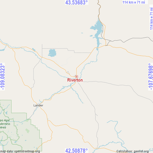
Riverton GPS coordinates[2]
43° 1' 29.856" North, 108° 22' 48.36" West
| Map corner | latitude | longitude |
|---|---|---|
| Upper-left | 43.53683°, | -109.08323° |
| Center: | 43.02496°, | -108.3801° |
| Lower-right: | 42.50878°, | -107.67698° |
| Map W x H: | 114.3×114.3 km | = 71×71mi |
| max Lat: | 71.29058° ⇑16.5% North |
| Riverton: | 43.02496° |
| min Lat: | ⇓83.5% South 19.06759° |
| min Long | Riverton | max Long |
| -171.73463° | -108.3801° | -66.98998° |
| W 14.8%⇐ | ⇒85.2% E |
Elevation
Elevation of Riverton is 1512 m = 4961 ft, and this is 1217.2 m = 3993 ft above average elevation for this country.
| Max E: |
3189 m = 10463 ft | 3.3% |
| Riverton | 1512 m 4961 ft | |
| Avg. | 294.8 m = 967 ft | |
Min E: |
-60 m = -197 ft | 96.7% |
See also: United States elevation on elevation.city.
Geographical zone
Riverton is located in North temperate zone (between Tropic of Cancer and the Arctic Circle). Distance of this Northern Tropic circle is 2178 km =1353.3 mi to South.| Distance of | km | miles | from Riverton |
|---|---|---|---|
| North Pole | 5223.1 | 3245.5 | to North |
| Arctic Circle | 2617.2 | 1626.3 | to North |
| Tropic Cancer | 2178 | 1353.3 | to South |
| Equator | 4783.9 | 2972.6 | to South |


Nearby cities:
15 places around Riverton: (largest is in red/bold)
• Arapahoe
11.3 km =7 mi,  231°
231°
• Basin
153.1 km =95.1 mi,  10°
10°
• Big Piney
151.5 km =94.1 mi,  249°
249°
• Dubois
115.9 km =72 mi,  299°
299°
• Ethete
31.9 km =19.8 mi,  270°
270°
• Fort Washakie
40.9 km =25.4 mi, 267°
• Lander
35.6 km =22.1 mi, 233°
• Lucerne
80.6 km =50.1 mi, 11°
• Marbleton
150.5 km =93.5 mi, 249°
• Pinedale
121.8 km =75.7 mi,  261°
261°
• Shoshoni
32.1 km =19.9 mi,  43°
43°
• Thermopolis
70.4 km =43.7 mi, 11°
• Vista West
159.3 km =99 mi,  96°
96°
• Washakie Ten
124.9 km =77.6 mi,  17°
17°
• Worland
115.5 km =71.8 mi, 17°
Sources, notices
• [Note1] Compared only with cities in United States existing in our database
• [Src1] Map data: © OpenStreetMap contributors (CC-BY-SA)
• [Src2] Other city data from geonames.org with taken over terms of usage.
• [Src3] Geographical zone / Annual Mean Temperature by Robert A. Rohde @ Wikipedia
