Pa‘auilo geodata
Pa‘auilo (Hawaii) is a populated place; located in United States in Pacific/Honolulu (GMT-10) time zone. With population of 595 people, there are 19757 cities with bigger population in this country. Compared to other cities in United States, 99.8% of cities are located further ↑North; 99.3% of cities are located further →East and 55.1% of cities have lower elevation than Pa‘auilo. Note1


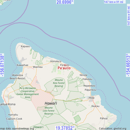
Pa‘auilo GPS coordinates[2]
20° 2' 25.62" North, 155° 22' 5.7" West
| Map corner | latitude | longitude |
|---|---|---|
| Upper-left | 20.6996°, | -156.07138° |
| Center: | 20.04045°, | -155.36825° |
| Lower-right: | 19.37852°, | -154.66513° |
| Map W x H: | 146.9×146.9 km | = 91.3×91.3mi |
| max Lat: | 71.29058° ⇑99.8% North |
| Pa‘auilo: | 20.04045° |
| min Lat: | ⇓0.2% South 19.06759° |
| min Long | Pa‘auilo | max Long |
| -171.73463° | -155.36825° | -66.98998° |
| W 0.7%⇐ | ⇒99.3% E |
Elevation
Elevation of Pa‘auilo is 219 m = 719 ft, and this is 75.8 m = 249 ft below average elevation for this country.
| Max E: |
3189 m = 10463 ft | 44.9% |
| Avg. | 294.8 m = 967 ft | |
| Pa‘auilo | 219 m = 719 ft | |
Min E: |
-60 m = -197 ft | 55.1% |
See also: United States elevation on elevation.city.
Geographical zone
Pa‘auilo is located in North Torrid zone (between Equator and Tropic of Cancer). Distance of this Northern Tropic circle is 377.6 km =234.6 mi to North.| Distance of | km | miles | from Pa‘auilo |
|---|---|---|---|
| North Pole | 7778.8 | 4833.5 | to North |
| Arctic Circle | 5172.9 | 3214.3 | to North |
| Tropic Cancer | 377.6 | 234.6 | to North |
| Equator | 2228.3 | 1384.6 | to South |


Nearby cities:
15 places around Pa‘auilo: (largest is in red/bold)
• Hilo
45.1 km =28 mi,  139°
139°
• Honoka‘a
11.2 km =7 mi,  292°
292°
• Honomu
32.1 km =19.9 mi,  125°
125°
• Hāwī
53.5 km =33.2 mi, 294°
• Kapaau
50.1 km =31.1 mi,  295°
295°
• Kea‘au
57.9 km =36 mi, 143°
• Kurtistown
58.5 km =36.4 mi,  146°
146°
• Laupāhoehoe
15 km =9.3 mi,  113°
113°
• Mountain View
60.4 km =37.5 mi, 153°
• Pepeekeo
35.7 km =22.2 mi, 130°
• Puako
49.5 km =30.8 mi,  260°
260°
• Pāpa‘ikou
40.2 km =25 mi, 134°
• Waikoloa
45.4 km =28.2 mi, 255°
• Waimea
31.9 km =19.8 mi,  266°
266°
• Wainaku
43.6 km =27.1 mi, 139°
Sources, notices
• [Note1] Compared only with cities in United States existing in our database
• [Src1] Map data: © OpenStreetMap contributors (CC-BY-SA)
• [Src2] Other city data from geonames.org with taken over terms of usage.
• [Src3] Geographical zone / Annual Mean Temperature by Robert A. Rohde @ Wikipedia
