Delta Junction geodata
Delta Junction (Alaska) is a populated place; located in United States in America/Anchorage (GMT-8) time zone. With population of 929 people, there are 16802 cities with bigger population in this country. Compared to other cities in United States, 99.9% of cities are located further ↓South; 98.9% of cities are located further →East and 80.4% of cities have lower elevation than Delta Junction. Note1


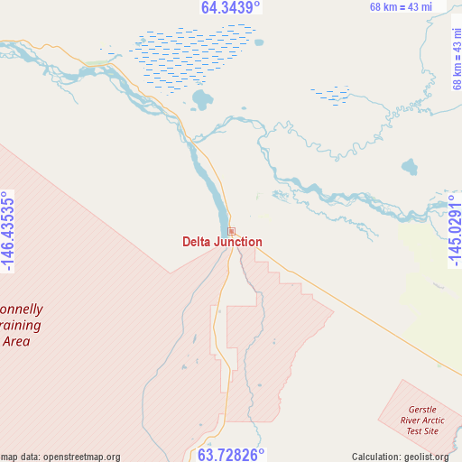
Delta Junction GPS coordinates[2]
64° 2' 16.008" North, 145° 43' 55.992" West
| Map corner | latitude | longitude |
|---|---|---|
| Upper-left | 64.3439°, | -146.43535° |
| Center: | 64.03778°, | -145.73222° |
| Lower-right: | 63.72826°, | -145.0291° |
| Map W x H: | 68.5×68.4 km | = 42.6×42.5mi |
| max Lat: | 71.29058° ⇑0.1% North |
| Delta Junction: | 64.03778° |
| min Lat: | ⇓99.9% South 19.06759° |
| min Long | Delta Junction | max Long |
| -171.73463° | -145.73222° | -66.98998° |
| W 1.1%⇐ | ⇒98.9% E |
Elevation
Elevation of Delta Junction is 357 m = 1171 ft, and this is 62.2 m = 204 ft above average elevation for this country.
| Max E: |
3189 m = 10463 ft | 19.6% |
| Delta Junction | 357 m 1171 ft | |
| Avg. | 294.8 m = 967 ft | |
Min E: |
-60 m = -197 ft | 80.4% |
See also: United States elevation on elevation.city.
Geographical zone
Delta Junction is located in North temperate zone (between Tropic of Cancer and the Arctic Circle). Distance of this North polar circle is 280.8 km =174.5 mi to North.| Distance of | km | miles | from Delta Junction |
|---|---|---|---|
| North Pole | 2886.7 | 1793.7 | to North |
| Arctic Circle | 280.8 | 174.5 | to North |
| Tropic Cancer | 4514.4 | 2805.1 | to South |
| Equator | 7120.3 | 4424.3 | to South |


Nearby cities:
15 places around Delta Junction: (largest is in red/bold)
• Badger
121.1 km =75.2 mi,  314°
314°
• Big Delta
13.8 km =8.6 mi,  337°
337°
• College
134.7 km =83.7 mi, 312°
• Deltana
31.1 km =19.3 mi,  126°
126°
• Eielson Air Force Base
94.3 km =58.6 mi,  317°
317°
• Ester
141.7 km =88 mi, 309°
• Fairbanks
130.3 km =81 mi, 313°
• Farmers Loop
135.1 km =83.9 mi, 315°
• Fort Greely
13.2 km =8.2 mi,  144°
144°
• Moose Creek
101 km =62.8 mi, 317°
• North Pole
111 km =69 mi, 315°
• Pleasant Valley
108.5 km =67.4 mi,  329°
329°
• Salcha
78.2 km =48.6 mi, 313°
• South Van Horn
130.8 km =81.3 mi, 311°
• Two Rivers
111.9 km =69.5 mi, 325°
Sources, notices
• [Note1] Compared only with cities in United States existing in our database
• [Src1] Map data: © OpenStreetMap contributors (CC-BY-SA)
• [Src2] Other city data from geonames.org with taken over terms of usage.
• [Src3] Geographical zone / Annual Mean Temperature by Robert A. Rohde @ Wikipedia
