Ester geodata
Ester (Alaska) is a populated place; located in United States in America/Anchorage (GMT-8) time zone. With population of 2,422 people, there are 10795 cities with bigger population in this country. Compared to other cities in United States, 99.9% of cities are located further ↓South; 98.9% of cities are located further →East and 53.6% of cities have higher elevation than Ester. Note1


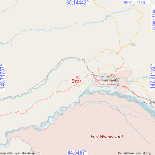
Ester GPS coordinates[2]
64° 50' 49.992" North, 148° 0' 51.984" West
| Map corner | latitude | longitude |
|---|---|---|
| Upper-left | 65.14442°, | -148.71757° |
| Center: | 64.84722°, | -148.01444° |
| Lower-right: | 64.5467°, | -147.31132° |
| Map W x H: | 66.5×66.5 km | = 41.3×41.3mi |
| max Lat: | 71.29058° ⇑0.1% North |
| Ester: | 64.84722° |
| min Lat: | ⇓99.9% South 19.06759° |
| min Long | Ester | max Long |
| -171.73463° | -148.01444° | -66.98998° |
| W 1.1%⇐ | ⇒98.9% E |
Elevation
Elevation of Ester is 185 m = 607 ft, and this is 109.8 m = 360 ft below average elevation for this country.
| Max E: |
3189 m = 10463 ft | 53.6% |
| Avg. | 294.8 m = 967 ft | |
| Ester | 185 m = 607 ft | |
Min E: |
-60 m = -197 ft | 46.4% |
See also: United States elevation on elevation.city.
Geographical zone
Ester is located in North temperate zone (between Tropic of Cancer and the Arctic Circle). Distance of this North polar circle is 190.8 km =118.6 mi to North.| Distance of | km | miles | from Ester |
|---|---|---|---|
| North Pole | 2796.7 | 1737.8 | to North |
| Arctic Circle | 190.8 | 118.6 | to North |
| Tropic Cancer | 4604.4 | 2861 | to South |
| Equator | 7210.3 | 4480.3 | to South |


Nearby cities:
15 places around Ester: (largest is in red/bold)
• Badger
23.4 km =14.5 mi,  102°
102°
• Big Delta
129.5 km =80.5 mi,  126°
126°
• College
10.1 km =6.3 mi,  83°
83°
• Delta Junction
141.7 km =88 mi, 129°
• Eielson Air Force Base
49.9 km =31 mi,  114°
114°
• Fairbanks
14.1 km =8.8 mi,  94°
94°
• Farmers Loop
16.4 km =10.2 mi,  65°
65°
• Fort Greely
154.6 km =96.1 mi, 130°
• Healy
119.3 km =74.1 mi,  202°
202°
• Moose Creek
44 km =27.3 mi, 110°
• North Pole
33.2 km =20.6 mi, 108°
• Pleasant Valley
54.2 km =33.7 mi, 85°
• Salcha
63.9 km =39.7 mi,  124°
124°
• South Van Horn
11.5 km =7.1 mi, 111°
• Two Rivers
46.2 km =28.7 mi, 86°
Sources, notices
• [Note1] Compared only with cities in United States existing in our database
• [Src1] Map data: © OpenStreetMap contributors (CC-BY-SA)
• [Src2] Other city data from geonames.org with taken over terms of usage.
• [Src3] Geographical zone / Annual Mean Temperature by Robert A. Rohde @ Wikipedia
