Happy Valley geodata
Happy Valley (Alaska) is a populated place; located in United States in America/Anchorage (GMT-8) time zone. With population of 593 people, there are 19785 cities with bigger population in this country. Compared to other cities in United States, 99.6% of cities are located further ↓South; 99.2% of cities are located further →East and 74.9% of cities have higher elevation than Happy Valley. Note1


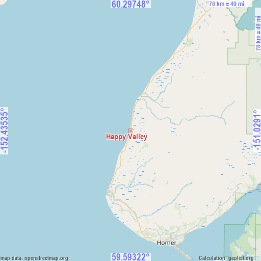
Happy Valley GPS coordinates[2]
59° 56' 49.992" North, 151° 43' 55.992" West
| Map corner | latitude | longitude |
|---|---|---|
| Upper-left | 60.29748°, | -152.43535° |
| Center: | 59.94722°, | -151.73222° |
| Lower-right: | 59.59322°, | -151.0291° |
| Map W x H: | 78.3×78.3 km | = 48.7×48.7mi |
| max Lat: | 71.29058° ⇑0.4% North |
| Happy Valley: | 59.94722° |
| min Lat: | ⇓99.6% South 19.06759° |
| min Long | Happy Valley | max Long |
| -171.73463° | -151.73222° | -66.98998° |
| W 0.8%⇐ | ⇒99.2% E |
Elevation
Elevation of Happy Valley is 72 m = 236 ft, and this is 222.8 m = 731 ft below average elevation for this country.
| Max E: |
3189 m = 10463 ft | 74.9% |
| Avg. | 294.8 m = 967 ft | |
| Happy Valley | 72 m = 236 ft | |
Min E: |
-60 m = -197 ft | 25.1% |
See also: United States elevation on elevation.city.
Geographical zone
Happy Valley is located in North temperate zone (between Tropic of Cancer and the Arctic Circle). Distance of this North polar circle is 735.7 km =457.1 mi to North.| Distance of | km | miles | from Happy Valley |
|---|---|---|---|
| North Pole | 3341.6 | 2076.4 | to North |
| Arctic Circle | 735.7 | 457.1 | to North |
| Tropic Cancer | 4059.6 | 2522.5 | to South |
| Equator | 6665.5 | 4141.7 | to South |


Nearby cities:
15 places around Happy Valley: (largest is in red/bold)
• Anchor Point
19.8 km =12.3 mi,  196°
196°
• Cohoe
52.4 km =32.6 mi,  26°
26°
• Diamond Ridge
31.7 km =19.7 mi,  162°
162°
• Fox River
44.3 km =27.5 mi,  102°
102°
• Fritz Creek
33.9 km =21.1 mi,  133°
133°
• Funny River
81.7 km =50.8 mi,  40°
40°
• Homer
35.4 km =22 mi, 163°
• Kalifornsky
57.8 km =35.9 mi, 25°
• Kasilof
50.3 km =31.3 mi, 30°
• Kenai
72.4 km =45 mi,  21°
21°
• Ninilchik
12 km =7.5 mi, 17°
• Ridgeway
74.2 km =46.1 mi, 28°
• Salamatof
77.7 km =48.3 mi, 17°
• Soldotna
70.7 km =43.9 mi, 31°
• Sterling
84.6 km =52.6 mi, 39°
Sources, notices
• [Note1] Compared only with cities in United States existing in our database
• [Src1] Map data: © OpenStreetMap contributors (CC-BY-SA)
• [Src2] Other city data from geonames.org with taken over terms of usage.
• [Src3] Geographical zone / Annual Mean Temperature by Robert A. Rohde @ Wikipedia
