Millis-Clicquot geodata
Millis-Clicquot (Massachusetts) is a populated place; located in United States in America/New_York (GMT-4) time zone. With population of 4,403 people, there are 7749 cities with bigger population in this country. Compared to other cities in United States, 77% of cities are located further ↓South; 96.9% of cities are located further ←West and 78.4% of cities have higher elevation than Millis-Clicquot. Note1


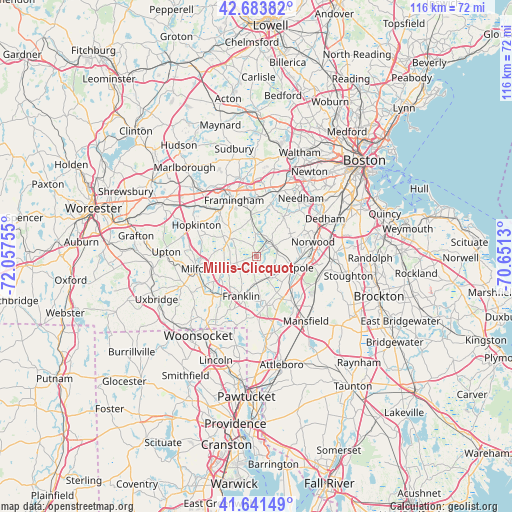
Millis-Clicquot GPS coordinates[2]
42° 9' 53.28" North, 71° 21' 15.912" West
| Map corner | latitude | longitude |
|---|---|---|
| Upper-left | 42.68382°, | -72.05755° |
| Center: | 42.1648°, | -71.35442° |
| Lower-right: | 41.64149°, | -70.6513° |
| Map W x H: | 115.9×115.9 km | = 72×72mi |
| max Lat: | 71.29058° ⇑23% North |
| Millis-Clicquot: | 42.1648° |
| min Lat: | ⇓77% South 19.06759° |
| min Long | Millis-Clicquot | max Long |
| -171.73463° | -71.35442° | -66.98998° |
| W 96.9%⇐ | ⇒3.1% E |
Elevation
Elevation of Millis-Clicquot is 54 m = 177 ft, and this is 240.8 m = 790 ft below average elevation for this country.
| Max E: |
3189 m = 10463 ft | 78.4% |
| Avg. | 294.8 m = 967 ft | |
| Millis-Clicquot | 54 m = 177 ft | |
Min E: |
-60 m = -197 ft | 21.6% |
See also: United States elevation on elevation.city.
Geographical zone
Millis-Clicquot is located in North temperate zone (between Tropic of Cancer and the Arctic Circle). Distance of this Northern Tropic circle is 2082.4 km =1293.9 mi to South.| Distance of | km | miles | from Millis-Clicquot |
|---|---|---|---|
| North Pole | 5318.8 | 3304.9 | to North |
| Arctic Circle | 2712.9 | 1685.7 | to North |
| Tropic Cancer | 2082.4 | 1293.9 | to South |
| Equator | 4688.3 | 2913.2 | to South |


Nearby cities:
15 places around Millis-Clicquot: (largest is in red/bold)
• Bellingham
13.2 km =8.2 mi,  228°
228°
• Dover
10.8 km =6.7 mi,  33°
33°
• Franklin
9.7 km =6 mi,  201°
201°
• Holliston
7 km =4.3 mi,  304°
304°
• Medfield
4.7 km =2.9 mi,  57°
57°
• Medway
4.3 km =2.7 mi, 233°
• Milford
13.6 km =8.5 mi,  258°
258°
• Millis
0.4 km =0.2 mi,  317°
317°
• Natick
13.2 km =8.2 mi,  1°
1°
• Norfolk
5.6 km =3.5 mi,  154°
154°
• Norwood
13.2 km =8.2 mi,  75°
75°
• Sherborn
8.3 km =5.2 mi,  351°
351°
• Walpole
9 km =5.6 mi,  106°
106°
• Westwood
12 km =7.5 mi, 62°
• Wrentham
11.1 km =6.9 mi,  168°
168°
Sources, notices
• [Note1] Compared only with cities in United States existing in our database
• [Src1] Map data: © OpenStreetMap contributors (CC-BY-SA)
• [Src2] Other city data from geonames.org with taken over terms of usage.
• [Src3] Geographical zone / Annual Mean Temperature by Robert A. Rohde @ Wikipedia
