Claverack-Red Mills geodata
Claverack-Red Mills (New York) is a populated place; located in United States in America/New_York (GMT-4) time zone. With population of 913 people, there are 16907 cities with bigger population in this country. Compared to other cities in United States, 77.6% of cities are located further ↓South; 91.9% of cities are located further ←West and 76% of cities have higher elevation than Claverack-Red Mills. Note1


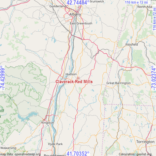
Claverack-Red Mills GPS coordinates[2]
42° 13' 34.788" North, 73° 43' 36.696" West
| Map corner | latitude | longitude |
|---|---|---|
| Upper-left | 42.74484°, | -74.42999° |
| Center: | 42.22633°, | -73.72686° |
| Lower-right: | 41.70352°, | -73.02374° |
| Map W x H: | 115.8×115.8 km | = 72×72mi |
| max Lat: | 71.29058° ⇑22.4% North |
| Claverack-Red Mills: | 42.22633° |
| min Lat: | ⇓77.6% South 19.06759° |
| min Long | Claverack-Red M | max Long |
| -171.73463° | -73.72686° | -66.98998° |
| W 91.9%⇐ | ⇒8.1% E |
Elevation
Elevation of Claverack-Red Mills is 66 m = 217 ft, and this is 228.8 m = 751 ft below average elevation for this country.
| Max E: |
3189 m = 10463 ft | 76% |
| Avg. | 294.8 m = 967 ft | |
| Claverack-Red Mills | 66 m = 217 ft | |
Min E: |
-60 m = -197 ft | 24% |
See also: United States elevation on elevation.city.
Geographical zone
Claverack-Red Mills is located in North temperate zone (between Tropic of Cancer and the Arctic Circle). Distance of this Northern Tropic circle is 2089.2 km =1298.2 mi to South.| Distance of | km | miles | from Claverack-Red Mills |
|---|---|---|---|
| North Pole | 5311.9 | 3300.7 | to North |
| Arctic Circle | 2706 | 1681.4 | to North |
| Tropic Cancer | 2089.2 | 1298.2 | to South |
| Equator | 4695.1 | 2917.4 | to South |


Nearby cities:
15 places around Claverack-Red Mills: (largest is in red/bold)
• Athens
7.8 km =4.8 mi,  299°
299°
• Catskill
11.4 km =7.1 mi,  264°
264°
• Chatham
18.8 km =11.7 mi,  35°
35°
• Copake Lake
15.3 km =9.5 mi,  129°
129°
• Coxsackie
15.2 km =9.4 mi,  335°
335°
• Germantown
17 km =10.6 mi,  233°
233°
• Ghent
14.7 km =9.1 mi, 38°
• Hudson
6 km =3.7 mi, 299°
• Jefferson Heights
12.8 km =8 mi,  273°
273°
• Kinderhook
18.9 km =11.7 mi,  7°
7°
• Lorenz Park
5.4 km =3.4 mi,  320°
320°
• Oakdale
5.2 km =3.2 mi, 302°
• Philmont
6.5 km =4 mi,  67°
67°
• Stottville
6.7 km =4.2 mi,  351°
351°
• Valatie
21.3 km =13.2 mi, 11°
Sources, notices
• [Note1] Compared only with cities in United States existing in our database
• [Src1] Map data: © OpenStreetMap contributors (CC-BY-SA)
• [Src2] Other city data from geonames.org with taken over terms of usage.
• [Src3] Geographical zone / Annual Mean Temperature by Robert A. Rohde @ Wikipedia
