Quantico Station geodata
Quantico Station (Virginia) is a populated place; located in United States in America/New_York (GMT-4) time zone. With population of 4,452 people, there are 7692 cities with bigger population in this country. Compared to other cities in United States, 58.6% of cities are located further ↑North; 79.5% of cities are located further ←West and 80.6% of cities have higher elevation than Quantico Station. Note1


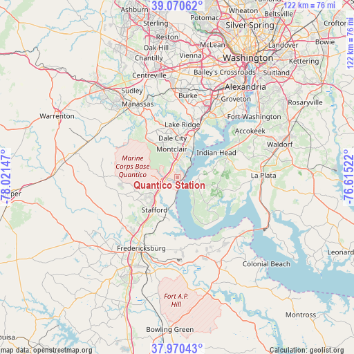
Quantico Station GPS coordinates[2]
38° 31' 21.468" North, 77° 19' 6.024" West
| Map corner | latitude | longitude |
|---|---|---|
| Upper-left | 39.07062°, | -78.02147° |
| Center: | 38.52263°, | -77.31834° |
| Lower-right: | 37.97043°, | -76.61522° |
| Map W x H: | 122.3×122.3 km | = 76×76mi |
| max Lat: | 71.29058° ⇑58.6% North |
| Quantico Station: | 38.52263° |
| min Lat: | ⇓41.4% South 19.06759° |
| min Long | Quantico Statio | max Long |
| -171.73463° | -77.31834° | -66.98998° |
| W 79.5%⇐ | ⇒20.5% E |
Elevation
Elevation of Quantico Station is 44 m = 144 ft, and this is 250.8 m = 823 ft below average elevation for this country.
| Max E: |
3189 m = 10463 ft | 80.6% |
| Avg. | 294.8 m = 967 ft | |
| Quantico Station | 44 m = 144 ft | |
Min E: |
-60 m = -197 ft | 19.4% |
See also: United States elevation on elevation.city.
Geographical zone
Quantico Station is located in North temperate zone (between Tropic of Cancer and the Arctic Circle). Distance of this Northern Tropic circle is 1677.4 km =1042.3 mi to South.| Distance of | km | miles | from Quantico Station |
|---|---|---|---|
| North Pole | 5723.7 | 3556.5 | to North |
| Arctic Circle | 3117.9 | 1937.4 | to North |
| Tropic Cancer | 1677.4 | 1042.3 | to South |
| Equator | 4283.3 | 2661.5 | to South |


Nearby cities:
15 places around Quantico Station: (largest is in red/bold)
• Aquia Harbour
9.1 km =5.7 mi,  222°
222°
• Boswell's Corner
5.1 km =3.2 mi,  247°
247°
• Cherry Hill
6.9 km =4.3 mi,  40°
40°
• Dale City
12.7 km =7.9 mi,  2°
2°
• Dumfries
5.1 km =3.2 mi,  350°
350°
• Independent Hill
16.3 km =10.1 mi,  320°
320°
• Indian Head
16.1 km =10 mi,  57°
57°
• Lake Ridge
18.5 km =11.5 mi,  5°
5°
• Montclair
10 km =6.2 mi, 349°
• Occoquan
18.6 km =11.6 mi,  15°
15°
• Potomac Heights
18.2 km =11.3 mi, 58°
• Potomac Mills
13.9 km =8.6 mi, 8°
• Stafford
13.7 km =8.5 mi, 215°
• Triangle
3.1 km =1.9 mi,  329°
329°
• Woodbridge
16.2 km =10.1 mi, 21°
Sources, notices
• [Note1] Compared only with cities in United States existing in our database
• [Src1] Map data: © OpenStreetMap contributors (CC-BY-SA)
• [Src2] Other city data from geonames.org with taken over terms of usage.
• [Src3] Geographical zone / Annual Mean Temperature by Robert A. Rohde @ Wikipedia
