Potomac Heights geodata
Potomac Heights (Maryland) is a populated place; located in United States in America/New_York (GMT-4) time zone. With population of 1,117 people, there are 15584 cities with bigger population in this country. Compared to other cities in United States, 58.1% of cities are located further ↑North; 80% of cities are located further ←West and 86.2% of cities have higher elevation than Potomac Heights. Note1


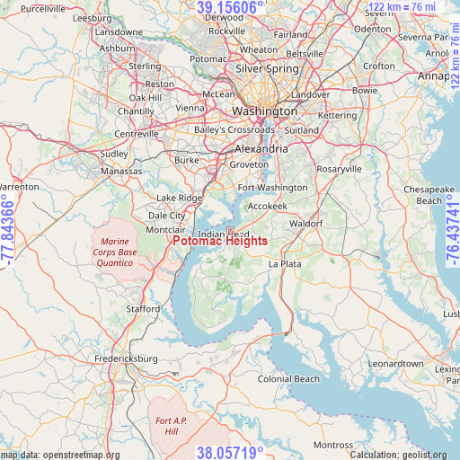
Potomac Heights GPS coordinates[2]
38° 36' 31.428" North, 77° 8' 25.908" West
| Map corner | latitude | longitude |
|---|---|---|
| Upper-left | 39.15606°, | -77.84366° |
| Center: | 38.60873°, | -77.14053° |
| Lower-right: | 38.05719°, | -76.43741° |
| Map W x H: | 122.2×122.2 km | = 75.9×75.9mi |
| max Lat: | 71.29058° ⇑58.1% North |
| Potomac Heights: | 38.60873° |
| min Lat: | ⇓41.9% South 19.06759° |
| min Long | Potomac Heights | max Long |
| -171.73463° | -77.14053° | -66.98998° |
| W 80%⇐ | ⇒20% E |
Elevation
Elevation of Potomac Heights is 25 m = 82 ft, and this is 269.8 m = 885 ft below average elevation for this country.
| Max E: |
3189 m = 10463 ft | 86.2% |
| Avg. | 294.8 m = 967 ft | |
| Potomac Heights | 25 m = 82 ft | |
Min E: |
-60 m = -197 ft | 13.8% |
See also: United States elevation on elevation.city.
Geographical zone
Potomac Heights is located in North temperate zone (between Tropic of Cancer and the Arctic Circle). Distance of this Northern Tropic circle is 1687 km =1048.3 mi to South.| Distance of | km | miles | from Potomac Heights |
|---|---|---|---|
| North Pole | 5714.2 | 3550.6 | to North |
| Arctic Circle | 3108.3 | 1931.4 | to North |
| Tropic Cancer | 1687 | 1048.3 | to South |
| Equator | 4292.9 | 2667.5 | to South |


Nearby cities:
15 places around Potomac Heights: (largest is in red/bold)
• Accokeek
11.7 km =7.3 mi,  56°
56°
• Bennsville
11.2 km =7 mi,  89°
89°
• Bryans Road
6.2 km =3.9 mi,  70°
70°
• Cherry Hill
11.8 km =7.3 mi,  248°
248°
• Fort Belvoir
11.5 km =7.1 mi,  357°
357°
• Indian Head
2.1 km =1.3 mi,  243°
243°
• Laurel Hill
14.6 km =9.1 mi,  325°
325°
• Lorton
13 km =8.1 mi,  324°
324°
• Mount Vernon
12.6 km =7.8 mi,  13°
13°
• Newington
14.9 km =9.3 mi,  345°
345°
• Occoquan
13.3 km =8.3 mi,  308°
308°
• Pomfret
10.2 km =6.3 mi,  110°
110°
• Potomac Mills
14 km =8.7 mi,  287°
287°
• Woodbridge
11 km =6.8 mi,  300°
300°
• Woodlawn
12 km =7.5 mi,  3°
3°
Sources, notices
• [Note1] Compared only with cities in United States existing in our database
• [Src1] Map data: © OpenStreetMap contributors (CC-BY-SA)
• [Src2] Other city data from geonames.org with taken over terms of usage.
• [Src3] Geographical zone / Annual Mean Temperature by Robert A. Rohde @ Wikipedia
