Rising Sun-Lebanon geodata
Rising Sun-Lebanon (Delaware) is a populated place; located in United States in America/New_York (GMT-4) time zone. With population of 3,391 people, there are 9010 cities with bigger population in this country. Compared to other cities in United States, 53.9% of cities are located further ↑North; 85.6% of cities are located further ←West and 95.7% of cities have higher elevation than Rising Sun-Lebanon. Note1


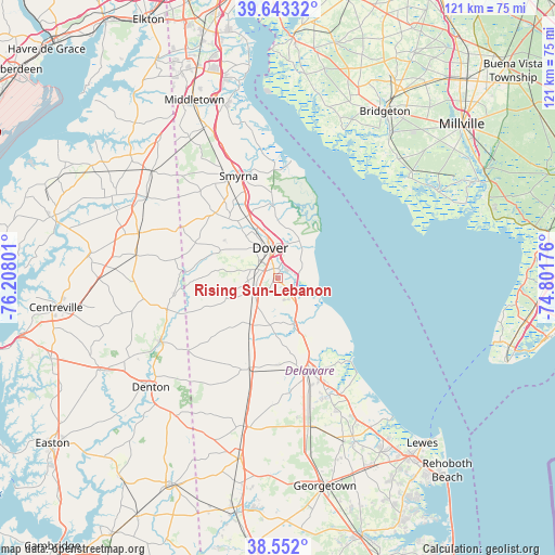
Rising Sun-Lebanon GPS coordinates[2]
39° 5' 59.172" North, 75° 30' 17.568" West
| Map corner | latitude | longitude |
|---|---|---|
| Upper-left | 39.64332°, | -76.20801° |
| Center: | 39.09977°, | -75.50488° |
| Lower-right: | 38.552°, | -74.80176° |
| Map W x H: | 121.3×121.3 km | = 75.4×75.4mi |
| max Lat: | 71.29058° ⇑53.9% North |
| Rising Sun-Lebanon: | 39.09977° |
| min Lat: | ⇓46.1% South 19.06759° |
| min Long | Rising Sun-Leba | max Long |
| -171.73463° | -75.50488° | -66.98998° |
| W 85.6%⇐ | ⇒14.4% E |
Elevation
Elevation of Rising Sun-Lebanon is 8 m = 26 ft, and this is 286.8 m = 941 ft below average elevation for this country.
| Max E: |
3189 m = 10463 ft | 95.7% |
| Avg. | 294.8 m = 967 ft | |
| Rising Sun-Lebanon | 8 m = 26 ft | |
Min E: |
-60 m = -197 ft | 4.3% |
See also: United States elevation on elevation.city.
Geographical zone
Rising Sun-Lebanon is located in North temperate zone (between Tropic of Cancer and the Arctic Circle). Distance of this Northern Tropic circle is 1741.6 km =1082.2 mi to South.| Distance of | km | miles | from Rising Sun-Lebanon |
|---|---|---|---|
| North Pole | 5659.6 | 3516.7 | to North |
| Arctic Circle | 3053.7 | 1897.5 | to North |
| Tropic Cancer | 1741.6 | 1082.2 | to South |
| Equator | 4347.5 | 2701.4 | to South |


Nearby cities:
15 places around Rising Sun-Lebanon: (largest is in red/bold)
• Camden
3.5 km =2.2 mi,  295°
295°
• Cheswold
15 km =9.3 mi,  332°
332°
• Dover
6.7 km =4.2 mi,  345°
345°
• Dover Base Housing
2.7 km =1.7 mi,  42°
42°
• Felton
12 km =7.5 mi,  211°
211°
• Frederica
10.6 km =6.6 mi,  161°
161°
• Harrington
20.6 km =12.8 mi,  197°
197°
• Highland Acres
2.8 km =1.7 mi, 328°
• Kent Acres
4 km =2.5 mi, 334°
• Milford
21.8 km =13.5 mi, 162°
• Riverview
8.2 km =5.1 mi,  183°
183°
• Rodney Village
4.3 km =2.7 mi, 326°
• Smyrna
23.8 km =14.8 mi,  338°
338°
• Woodside East
4.6 km =2.9 mi,  218°
218°
• Wyoming
5.1 km =3.2 mi,  293°
293°
Sources, notices
• [Note1] Compared only with cities in United States existing in our database
• [Src1] Map data: © OpenStreetMap contributors (CC-BY-SA)
• [Src2] Other city data from geonames.org with taken over terms of usage.
• [Src3] Geographical zone / Annual Mean Temperature by Robert A. Rohde @ Wikipedia
